
Geographic Region: USA-MISSOURI
Feature: MISSISSIPPI R. IN FLOOD, SED., AGR., WETLANDS, NEW MADRID, HOTCHKISS BEND
|
Geographic Region: USA-MISSOURI Feature: MISSISSIPPI R. IN FLOOD, SED., AGR., WETLANDS, NEW MADRID, HOTCHKISS BEND |
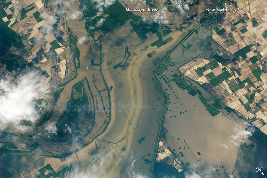 |
| Flooding near New Madrid, Missouri Note: This caption refers to the image versions labeled "NASA's Earth Observatory web site". Along a northward loop of the Mississippi River, near the city of New Madrid, flood water rested on agricultural fields in early May 2011. Taken from an altitude of 220 miles (350 kilometers) above the Earth, this astronaut photo shows muddy water filling a broad swath of cropland north of the river bend. In this image, north is toward the lower right. Crops normally carpet the landscape north of New Madrid. This portion of Missouri, however, lies near the Birds Point-New Madrid Floodway. On May 2, 2011, the U.S. Army Corps of Engineers breached a levee near the confluence of the Ohio and Mississippi Rivers. The move spared the residents of Cairo, Illinois, but filled the floodway. |
| Images: | All Available Images Low-Resolution 234k |
|
| Mission: | ISS027 |
|
| Roll - Frame: | E - 27026 |
|
| Geographical Name: | USA-MISSOURI |
|
| Features: | MISSISSIPPI R. IN FLOOD, SED., AGR., WETLANDS, NEW MADRID, HOTCHKISS BEND |
|
| Center Lat x Lon: | 36.6N x 89.4W |
|
| Film Exposure: | N=Normal exposure, U=Under exposed, O=Over exposed, F=out of Focus |
|
| Percentage of Cloud Cover-CLDP: | 25 |
|
| Camera:: | N2 |
|
| Camera Tilt: | 40 | LO=Low Oblique, HO=High Oblique, NV=Near Vertical |
| Camera Focal Length: | 400 |
|
| Nadir to Photo Center Direction: | SW | The direction from the nadir to the center point, N=North, S=South, E=East, W=West |
| Stereo?: | Y=Yes there is an adjacent picture of the same area, N=No there isn't |
|
| Orbit Number: | 3531 |
|
| Date: | 20110512 | YYYYMMDD |
| Time: | 160140 | GMT HHMMSS |
| Nadir Lat: | 38.8N |
Latitude of suborbital point of spacecraft |
| Nadir Lon: | 88.1W |
Longitude of suborbital point of spacecraft |
| Sun Azimuth: | 124 | Clockwise angle in degrees from north to the sun measured at the nadir point |
| Space Craft Altitude: | 184 | nautical miles |
| Sun Elevation: | 59 | Angle in degrees between the horizon and the sun, measured at the nadir point |
| Land Views: | |
|
| Water Views: | FLOODING, RIVER |
|
| Atmosphere Views: | |
|
| Man Made Views: | |
|
| City Views: | NEW MADRID |
|
Photo is not associated with any sequences | ||
| NASA Home Page |
JSC Home Page |
JSC Digital Image Collection |
Earth Science & Remote Sensing |
|
This service is provided by the International Space Station program and the JSC Earth Science & Remote Sensing Unit, ARES Division, Exploration Integration Science Directorate.

|