
Geographic Region: USA-TENNESSEE
Feature: MISSISSIPPI R. IN FLOOD, SED., AGR., WETLANDS, RIDGELY, LEVEES, CANALS
|
Geographic Region: USA-TENNESSEE Feature: MISSISSIPPI R. IN FLOOD, SED., AGR., WETLANDS, RIDGELY, LEVEES, CANALS |
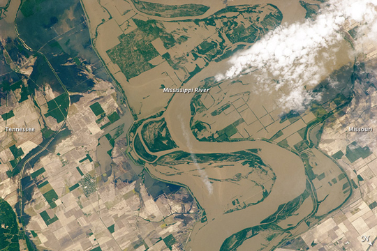 |
| Mississippi Floods in Missouri and Tennessee Note: This caption refers to the image versions labeled "NASA's Earth Observatory web site". Along the border between Tennessee and southeastern Missouri, the Mississippi River spilled onto floodplains, submerging agricultural fields on either side of the river. Taken from an altitude of 220 miles (350 kilometers) above the Earth, this astronaut photo shows muddy water resting on croplands. In this image, north is toward the lower right. The land cover around the Mississippi in this region is a combination of forest (dark green) and cropland (rectangles of green and brown). Where muddy water has inundated fields, the borders of some fields peek through the water, appearing as green lines. Along the eastern bank of the Mississippi (image center), a double loop pushes away from the river. This long-term feature (not the result of 2011 flooding) is likely transitioning to an oxbow lake. |
| Images: | All Available Images Low-Resolution 259k |
|
| Mission: | ISS027 |
|
| Roll - Frame: | E - 27023 |
|
| Geographical Name: | USA-TENNESSEE |
|
| Features: | MISSISSIPPI R. IN FLOOD, SED., AGR., WETLANDS, RIDGELY, LEVEES, CANALS |
|
| Center Lat x Lon: | 36.3N x 89.6W |
|
| Film Exposure: | N=Normal exposure, U=Under exposed, O=Over exposed, F=out of Focus |
|
| Percentage of Cloud Cover-CLDP: | 10 |
|
| Camera:: | N2 |
|
| Camera Tilt: | 42 | LO=Low Oblique, HO=High Oblique, NV=Near Vertical |
| Camera Focal Length: | 400 |
|
| Nadir to Photo Center Direction: | SW | The direction from the nadir to the center point, N=North, S=South, E=East, W=West |
| Stereo?: | Y=Yes there is an adjacent picture of the same area, N=No there isn't |
|
| Orbit Number: | 3531 |
|
| Date: | 20110512 | YYYYMMDD |
| Time: | 160137 | GMT HHMMSS |
| Nadir Lat: | 38.7N |
Latitude of suborbital point of spacecraft |
| Nadir Lon: | 88.3W |
Longitude of suborbital point of spacecraft |
| Sun Azimuth: | 123 | Clockwise angle in degrees from north to the sun measured at the nadir point |
| Space Craft Altitude: | 184 | nautical miles |
| Sun Elevation: | 59 | Angle in degrees between the horizon and the sun, measured at the nadir point |
| Land Views: | FOREST |
|
| Water Views: | FLOODING, LAKE, RIVER |
|
| Atmosphere Views: | |
|
| Man Made Views: | |
|
| City Views: | |
|
Photo is not associated with any sequences | ||
| NASA Home Page |
JSC Home Page |
JSC Digital Image Collection |
Earth Science & Remote Sensing |
|
This service is provided by the International Space Station program and the JSC Earth Science & Remote Sensing Unit, ARES Division, Exploration Integration Science Directorate.

|