
Geographic Region: USA-TENNESSEE
Feature: MISSISSIPPI R. IN FLOOD, SED., AGR., WETLANDS, BARFIELD PT., RUCKERS PT.
|
Geographic Region: USA-TENNESSEE Feature: MISSISSIPPI R. IN FLOOD, SED., AGR., WETLANDS, BARFIELD PT., RUCKERS PT. |
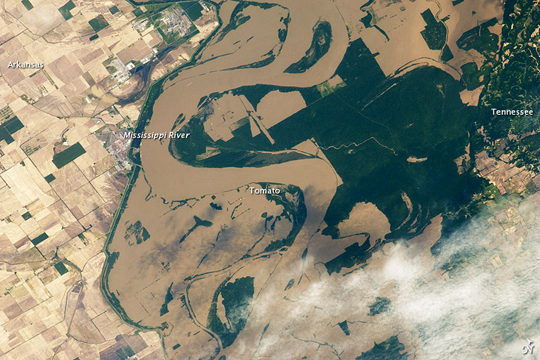 |
| Mississippi Floods in Arkansas and Tennessee Note: This caption refers to the image versions labeled "NASA's Earth Observatory web site". The Mississippi River spilled over its banks in Arkansas and Tennessee on May 12, 2011, as the International Space Station passed overhead. This astronaut photograph shows muddy water sitting on floodplains around Tomato, Arkansas, as well as extensive flooding to the north. Flood waters around Tomato appear confined by an embankment in the west. The embankment extends southward from a bend in the Mississippi. West of the embankment lies a patchwork of agricultural fields. East of the river lies an expanse of dark green forest, the Anderson-Tully State Wildlife Management Area. |
| Images: | All Available Images Low-Resolution 250k |
|
| Mission: | ISS027 |
|
| Roll - Frame: | E - 27019 |
|
| Geographical Name: | USA-TENNESSEE |
|
| Features: | MISSISSIPPI R. IN FLOOD, SED., AGR., WETLANDS, BARFIELD PT., RUCKERS PT. |
|
| Center Lat x Lon: | 35.8N x 89.7W |
|
| Film Exposure: | N=Normal exposure, U=Under exposed, O=Over exposed, F=out of Focus |
|
| Percentage of Cloud Cover-CLDP: | 25 |
|
| Camera:: | N2 |
|
| Camera Tilt: | 44 | LO=Low Oblique, HO=High Oblique, NV=Near Vertical |
| Camera Focal Length: | 400 |
|
| Nadir to Photo Center Direction: | S | The direction from the nadir to the center point, N=North, S=South, E=East, W=West |
| Stereo?: | Y=Yes there is an adjacent picture of the same area, N=No there isn't |
|
| Orbit Number: | 3531 |
|
| Date: | 20110512 | YYYYMMDD |
| Time: | 160133 | GMT HHMMSS |
| Nadir Lat: | 38.5N |
Latitude of suborbital point of spacecraft |
| Nadir Lon: | 88.5W |
Longitude of suborbital point of spacecraft |
| Sun Azimuth: | 123 | Clockwise angle in degrees from north to the sun measured at the nadir point |
| Space Craft Altitude: | 184 | nautical miles |
| Sun Elevation: | 59 | Angle in degrees between the horizon and the sun, measured at the nadir point |
| Land Views: | FOREST |
|
| Water Views: | FLOODING, RIVER |
|
| Atmosphere Views: | |
|
| Man Made Views: | |
|
| City Views: | |
|
Photo is not associated with any sequences | ||
| NASA Home Page |
JSC Home Page |
JSC Digital Image Collection |
Earth Science & Remote Sensing |
|
This service is provided by the International Space Station program and the JSC Earth Science & Remote Sensing Unit, ARES Division, Exploration Integration Science Directorate.

|