
Geographic Region: USA-MARYLAND
Feature: EASTERN SEABOARD AT NIGHT,PHILADELPHIA,NEW YORK,BALTIMORE,WASHINGTON
|
Geographic Region: USA-MARYLAND Feature: EASTERN SEABOARD AT NIGHT,PHILADELPHIA,NEW YORK,BALTIMORE,WASHINGTON |
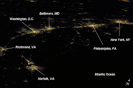 |
| Atlantic Seaboard Conurbation at Night, United States of America Note: This caption refers to the image versions labeled "NASA's Earth Observatory web site". As regional metropolitan areas expand in both physical area and population, they typically aggregate to form economically, politically, and to some extent socially linked entities known as conurbations - the term "megalopolis" has also been used. One of the largest conurbations in the world is located along the eastern coastline of the United States, and has been termed the Atlantic Seaboard Conurbation (ASC). The ASC extends over 1000 kilometers and includes the major economic, governmental, and cultural centers of Boston, MA; New York, NY; Philadelphia, PA; Baltimore, MD; and Washington, D.C. This astronaut photograph includes every metropolitan area in the ASC except for Boston, MA (located off the image to the northeast of New York, NY). The image was taken during local night, which highlights the position and extent of each metropolitan area along the eastern seaboard by their urban lighting patterns. The establishment and growth of the conurbation was facilitated by transportation networks (railroads, highways, and air travel routes) for transfer of goods, materials, and population between the metropolitan areas. Two other large metropolitan areas are visible in the image - Norfolk, VA and Richmond, VA at image lower left - but these are not considered to be part of the ASC. In contrast to the city lights that mark metropolitan areas and smaller communities along the sea coast and interior, the Atlantic Ocean appears as a featureless dark region occupying the lower right quarter of the image. |
| Images: | All Available Images Low-Resolution 151k |
|
| Mission: | ISS027 |
|
| Roll - Frame: | E - 20129 |
|
| Geographical Name: | USA-MARYLAND |
|
| Features: | EASTERN SEABOARD AT NIGHT,PHILADELPHIA,NEW YORK,BALTIMORE,WASHINGTON |
|
| Center Lat x Lon: | 39.0N x 76W |
|
| Film Exposure: | N=Normal exposure, U=Under exposed, O=Over exposed, F=out of Focus |
|
| Percentage of Cloud Cover-CLDP: | 10 |
|
| Camera:: | N5 |
|
| Camera Tilt: | HO | LO=Low Oblique, HO=High Oblique, NV=Near Vertical |
| Camera Focal Length: | 80 |
|
| Nadir to Photo Center Direction: | NW | The direction from the nadir to the center point, N=North, S=South, E=East, W=West |
| Stereo?: | Y=Yes there is an adjacent picture of the same area, N=No there isn't |
|
| Orbit Number: | 2957 |
|
| Date: | 20110406 | YYYYMMDD |
| Time: | 051921 | GMT HHMMSS |
| Nadir Lat: | 33.2N |
Latitude of suborbital point of spacecraft |
| Nadir Lon: | 72.8W |
Longitude of suborbital point of spacecraft |
| Sun Azimuth: | 10 | Clockwise angle in degrees from north to the sun measured at the nadir point |
| Space Craft Altitude: | 186 | nautical miles |
| Sun Elevation: | -50 | Angle in degrees between the horizon and the sun, measured at the nadir point |
| Land Views: | COAST |
|
| Water Views: | OCEAN, SEA |
|
| Atmosphere Views: | |
|
| Man Made Views: | |
|
| City Views: | BALTIMORE, NORFOLK, PHILADELPHIA, RICHMOND, WASHINGTON |
|
Photo is not associated with any sequences | ||
| NASA Home Page |
JSC Home Page |
JSC Digital Image Collection |
Earth Science & Remote Sensing |
|
This service is provided by the International Space Station program and the JSC Earth Science & Remote Sensing Unit, ARES Division, Exploration Integration Science Directorate.

|