Geographic Region: CHINA
Feature: LAKE AYAKUM,RIVER DELTAS,SEDIMENTS
|
Geographic Region: CHINA Feature: LAKE AYAKUM,RIVER DELTAS,SEDIMENTS |
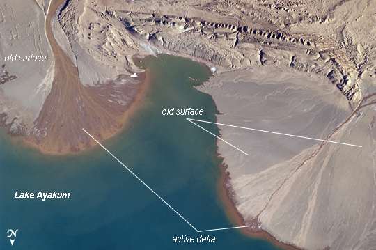 |
| River Deltas, Lake Ayakum, China (Tibet) The Tibetan Plateau contains numerous lakes that dot an otherwise arid landscape. Lake Ayakum is located near the northern boundary of the Plateau to the southeast of the Kunlun Mountains. While many of the small glacier- and snowmelt-fed streams that cross the Tibetan Plateau eventually give rise to major Southeast Asian rivers including the Mekong and Yangtze, some empty into saline lakes such as Lake Ayakum. This detailed astronaut photograph highlights two river deltas (image upper left and image lower right) formed along the southwestern shoreline of the lake. When sediments build up to the point that a river can no longer flow over them, it will jump to a new channel position and begin the process anew. Over geologic time the channels tend to sweep back and forth - similar to the motion of an automobile windshield wiper - to form the typical semi-circular or fan shape of the delta. Gray to tan surfaces of both deltas indicate prior positions of their respective river channels; the uniform coloration and smooth texture suggest that they are relatively old and are now inactive. In contrast, the younger and currently active delta surfaces can be recognized by reddish-brown sediment and clearly visible river channels. Lateral channel migration is particularly evident in the approximately 8 km wide active delta area at image upper left. The reddish coloration of the actively depositing sediment may indicate a change from the sources that formed the older parts of the deltas (or indicate weathering and soil formation on the older deposits), or an episodic input of dust or other material to the river catchments. |
| Images: | All Available Images Low-Resolution 199k |
|
| Mission: | ISS027 |
|
| Roll - Frame: | E - 16922 |
|
| Geographical Name: | CHINA |
|
| Features: | LAKE AYAKUM,RIVER DELTAS,SEDIMENTS |
|
| Center Lat x Lon: | 37.5N x 89.2E |
|
| Film Exposure: | N=Normal exposure, U=Under exposed, O=Over exposed, F=out of Focus |
|
| Percentage of Cloud Cover-CLDP: | 10 |
|
| Camera:: | N2 |
|
| Camera Tilt: | 23 | LO=Low Oblique, HO=High Oblique, NV=Near Vertical |
| Camera Focal Length: | 400 |
|
| Nadir to Photo Center Direction: | S | The direction from the nadir to the center point, N=North, S=South, E=East, W=West |
| Stereo?: | Y=Yes there is an adjacent picture of the same area, N=No there isn't |
|
| Orbit Number: | 3260 |
|
| Date: | 20110425 | YYYYMMDD |
| Time: | 111325 | GMT HHMMSS |
| Nadir Lat: | 38.8N |
Latitude of suborbital point of spacecraft |
| Nadir Lon: | 89.3E |
Longitude of suborbital point of spacecraft |
| Sun Azimuth: | 273 | Clockwise angle in degrees from north to the sun measured at the nadir point |
| Space Craft Altitude: | 185 | nautical miles |
| Sun Elevation: | 17 | Angle in degrees between the horizon and the sun, measured at the nadir point |
| Land Views: | PLATEAU |
|
| Water Views: | CHANNEL, DELTA, LAKE, RIVER, SEDIMENT |
|
| Atmosphere Views: | |
|
| Man Made Views: | |
|
| City Views: | |
|
Photo is not associated with any sequences | ||
| NASA Home Page |
JSC Home Page |
JSC Digital Image Collection |
Earth Science & Remote Sensing |
|
This service is provided by the International Space Station program and the JSC Earth Science & Remote Sensing Unit, ARES Division, Exploration Integration Science Directorate.

|