
Geographic Region: USA-NEVADA
Feature: LAS VEGAS AT NIGHT,CITY LIGHTS,MCCARRAN AIRPORT
|
Geographic Region: USA-NEVADA Feature: LAS VEGAS AT NIGHT,CITY LIGHTS,MCCARRAN AIRPORT |
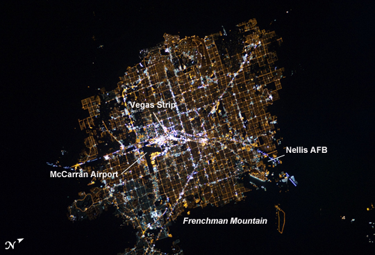 |
| Las Vegas at Night The Las Vegas metropolitan area is located near the southern tip of Nevada, within the Mohave Desert. While the city is famous for its casinos and resort hotels--Las Vegas bills itself as "the entertainment capital of the world"--the wider metropolitan area includes several other incorporated cities and unincorporated areas (not part of a state-recognized municipality). Astronauts on the International Space Station (ISS) observe and photograph numerous metropolitan areas when they are illuminated by sunlight, but the extent and pattern of these areas is perhaps best revealed at night by city lights. The surrounding darkness of the desert presents a stark contrast to the brightly lit street grid of the developed area. The Vegas Strip is reputed to be the brightest spot on Earth due to the concentration of lights on its hotels and casinos. The tarmac of McCarran International Airport is dark by comparison, while the airstrips of Nellis Air Force Base on the northeastern fringe are likewise dark. The dark mass of Frenchman Mountain borders the city to the east. The acquisition of focused nighttime images requires astronauts to track the target with the handheld camera while the ISS is moving at a speed of more than 7 kilometers per second (over 15,000 miles per hour) relative to the Earth's surface. This was achieved during ISS Expedition 6 using a homemade tracking device, but subsequent crews have needed to develop manual tracking skills. These skills, together with advances in digital camera technology, have enabled recent ISS crews to acquire striking nighttime images of the Earth (such as this recent image of the Nile River Delta). |
| Images: | All Available Images Low-Resolution 219k |
|
| Mission: | ISS026 |
|
| Roll - Frame: | E - 6255 |
|
| Geographical Name: | USA-NEVADA |
|
| Features: | LAS VEGAS AT NIGHT,CITY LIGHTS,MCCARRAN AIRPORT |
|
| Center Lat x Lon: | 36.1N x 115.2W |
|
| Film Exposure: | N=Normal exposure, U=Under exposed, O=Over exposed, F=out of Focus |
|
| Percentage of Cloud Cover-CLDP: | 0 |
|
| Camera:: | N5 |
|
| Camera Tilt: | HO | LO=Low Oblique, HO=High Oblique, NV=Near Vertical |
| Camera Focal Length: | 180 |
|
| Nadir to Photo Center Direction: | SW | The direction from the nadir to the center point, N=North, S=South, E=East, W=West |
| Stereo?: | Y=Yes there is an adjacent picture of the same area, N=No there isn't |
|
| Orbit Number: | 963 |
|
| Date: | 20101130 | YYYYMMDD |
| Time: | 120600 | GMT HHMMSS |
| Nadir Lat: | 40.0N |
Latitude of suborbital point of spacecraft |
| Nadir Lon: | 110.1W |
Longitude of suborbital point of spacecraft |
| Sun Azimuth: | 98 | Clockwise angle in degrees from north to the sun measured at the nadir point |
| Space Craft Altitude: | 189 | nautical miles |
| Sun Elevation: | -25 | Angle in degrees between the horizon and the sun, measured at the nadir point |
| Land Views: | DESERT, MOUNTAIN |
|
| Water Views: | |
|
| Atmosphere Views: | |
|
| Man Made Views: | AIRPORT |
|
| City Views: | LAS VEGAS |
|
Photo is not associated with any sequences | ||
| NASA Home Page |
JSC Home Page |
JSC Digital Image Collection |
Earth Science & Remote Sensing |
|
This service is provided by the International Space Station program and the JSC Earth Science & Remote Sensing Unit, ARES Division, Exploration Integration Science Directorate.

|