
Geographic Region: ARGENTINA
Feature: SAND DUNES,AGRICULTURAL FIELDS, MEDANO BLANCO,ATLANTIC OCEAN
|
Geographic Region: ARGENTINA Feature: SAND DUNES,AGRICULTURAL FIELDS, MEDANO BLANCO,ATLANTIC OCEAN |
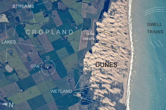 |
| Medano Blanco coastal dunes, Buenos Aires Province, Argentina The Medano Blanco (White Dunes) are a well known recreational area 35 km west of the twin cities of Nicochea-Quequen, one of the biggest ports in the province of Buenos Aires, central Argentina. The Medano Blanco dunes separate the Atlantic Ocean from intensive sunflower agricultural cropland, visible as the angular pattern of green and brown fields at image left. The dune field extends 3.5 km at its widest part. Narrow cordons of coastal dunes stretch along this part of Argentina's coastline for hundreds of km. Small streams, oriented towards the coast, cross the farmland at image upper left. Water from these is dammed behind the dunes, and even within the dunes, where wetlands flourish. This is the drier southern part of Buenos Aires province near the more arid and windier border with Patagonia--one of the windiest places on Earth. The effect of strong westerly winds (blowing bottom to top in this slightly oblique image) can be seen everywhere in this detailed astronaut photograph. The dune sand is blown from local beaches onshore where it forms the dunes. The prominent dune ridge crests are oriented at right angles to the prevailing wind. Geologists suspect that erosion by wind has excavated numerous hollows which now dot the farmland as small shallow lakes, seen here with more and less water. A stand of dark green trees has been planted on the upwind side of a health spa--located at the white dot (image center left) which is the roof of a stately building--as a protective barrier against the wind. The white fringe along the seashore is formed from lines of breaking waves. Crossing swell trains can be seen offshore in the Atlantic Ocean. The curvature of the swell pattern offshore also shows the effect of the westerly wind, and indeed drives the local sea current in this area--slightly more prominent onshore swells approach the coast from the southeast. The light brown tint of seawater nearer the shore is the fine muddy fraction of the coastal sediment being washed seaward (after being stirred up by wave action) and then east by the current. |
| Images: | All Available Images Low-Resolution 247k |
|
| Mission: | ISS026 |
|
| Roll - Frame: | E - 26761 |
|
| Geographical Name: | ARGENTINA |
|
| Features: | SAND DUNES,AGRICULTURAL FIELDS, MEDANO BLANCO,ATLANTIC OCEAN |
|
| Center Lat x Lon: | 38.7S x 59.1W |
|
| Film Exposure: | N=Normal exposure, U=Under exposed, O=Over exposed, F=out of Focus |
|
| Percentage of Cloud Cover-CLDP: | 10 |
|
| Camera:: | N2 |
|
| Camera Tilt: | 26 | LO=Low Oblique, HO=High Oblique, NV=Near Vertical |
| Camera Focal Length: | 800 |
|
| Nadir to Photo Center Direction: | W | The direction from the nadir to the center point, N=North, S=South, E=East, W=West |
| Stereo?: | Y=Yes there is an adjacent picture of the same area, N=No there isn't |
|
| Orbit Number: | 2148 |
|
| Date: | 20110213 | YYYYMMDD |
| Time: | 202933 | GMT HHMMSS |
| Nadir Lat: | 39.4S |
Latitude of suborbital point of spacecraft |
| Nadir Lon: | 57.7W |
Longitude of suborbital point of spacecraft |
| Sun Azimuth: | 275 | Clockwise angle in degrees from north to the sun measured at the nadir point |
| Space Craft Altitude: | 190 | nautical miles |
| Sun Elevation: | 27 | Angle in degrees between the horizon and the sun, measured at the nadir point |
| Land Views: | COAST, DUNE, EROSION |
|
| Water Views: | OCEAN, SEA, SEDIMENT, WAVE |
|
| Atmosphere Views: | |
|
| Man Made Views: | |
|
| City Views: | |
|
Photo is not associated with any sequences | ||
| NASA Home Page |
JSC Home Page |
JSC Digital Image Collection |
Earth Science & Remote Sensing |
|
This service is provided by the International Space Station program and the JSC Earth Science & Remote Sensing Unit, ARES Division, Exploration Integration Science Directorate.

|