
Geographic Region: MEXICO
Feature: PICO DE ORIZABA VOLCANO, LAHAR DEPOSITS, SIERRA NEGRA
|
Geographic Region: MEXICO Feature: PICO DE ORIZABA VOLCANO, LAHAR DEPOSITS, SIERRA NEGRA |
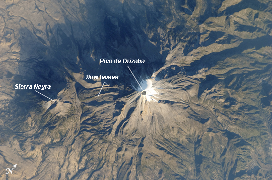 |
| Pico de Orizaba, Mexico The snow and ice-clad peak of Pico de Orizaba (also known as Citlaltepetl) boasts a summit elevation of 5675 meters (18619 feet) above sea level, making it the highest peak in Mexico and North America's highest volcano. It is also one of three volcanic peaks in Mexico--together with Popocatepetl and Iztaccihuatl-that retain summit glaciers. Pico de Orizaba is part of the Trans-Mexican Volcanic Belt that extends roughly east-west across Mexico. The last recorded eruption took place in 1846; while the volcano is considered dormant at present, geologists continue to investigate the potential hazards associated with a renewal of activity. Shadows accentuate several features of the Pico de Orizaba stratovolcano visible in this astronaut photograph from the International Space Station. The 300 meter deep summit crater is clearly visible against surrounding ice and snow cover at image center. Several lava flows extend down the flanks of the volcano, made readily visible by prominent cooling ridges along their sides known as flow levees - one of the most clearly visible examples is located on the southwest flank of the cone. The extinct Sierra Negra volcano to the southwest has a summit elevation of 4640 meters (15,223 feet) above sea level; while not as lofty as Pico de Orizaba, it is also one of Mexico's highest peaks. |
| Images: | All Available Images Low-Resolution 255k |
|
| Mission: | ISS026 |
|
| Roll - Frame: | E - 25437 |
|
| Geographical Name: | MEXICO |
|
| Features: | PICO DE ORIZABA VOLCANO, LAHAR DEPOSITS, SIERRA NEGRA |
|
| Center Lat x Lon: | 19.0N x 97.3W |
|
| Film Exposure: | N=Normal exposure, U=Under exposed, O=Over exposed, F=out of Focus |
|
| Percentage of Cloud Cover-CLDP: | 10 |
|
| Camera:: | N2 |
|
| Camera Tilt: | 8 | LO=Low Oblique, HO=High Oblique, NV=Near Vertical |
| Camera Focal Length: | 400 |
|
| Nadir to Photo Center Direction: | SW | The direction from the nadir to the center point, N=North, S=South, E=East, W=West |
| Stereo?: | Y=Yes there is an adjacent picture of the same area, N=No there isn't |
|
| Orbit Number: | 2097 |
|
| Date: | 20110210 | YYYYMMDD |
| Time: | 140316 | GMT HHMMSS |
| Nadir Lat: | 19.2N |
Latitude of suborbital point of spacecraft |
| Nadir Lon: | 96.9W |
Longitude of suborbital point of spacecraft |
| Sun Azimuth: | 111 | Clockwise angle in degrees from north to the sun measured at the nadir point |
| Space Craft Altitude: | 190 | nautical miles |
| Sun Elevation: | 14 | Angle in degrees between the horizon and the sun, measured at the nadir point |
| Land Views: | CRATER, VOLCANO |
|
| Water Views: | ICE |
|
| Atmosphere Views: | |
|
| Man Made Views: | |
|
| City Views: | |
|
Photo is not associated with any sequences | ||
| NASA Home Page |
JSC Home Page |
JSC Digital Image Collection |
Earth Science & Remote Sensing |
|
This service is provided by the International Space Station program and the JSC Earth Science & Remote Sensing Unit, ARES Division, Exploration Integration Science Directorate.

|