
Geographic Region: ERITREA
Feature: NABRO VOLCANO, LAVA FLOWS,ARUKU
|
Geographic Region: ERITREA Feature: NABRO VOLCANO, LAVA FLOWS,ARUKU |
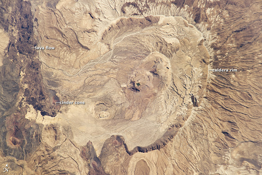 |
| Nabro Volcano Before Eruption Prior to June 12, 2011, the Nabro volcano in northeast Africa looked like it does in the image above. Then, on the night of June 12, 2011, the stratovolcano erupted for the first time in recorded history. It spewed ash and large amounts of sulfur dioxide gas--the highest levels ever detected from space, according to preliminary estimates from researchers at NASA's Goddard Space Flight Center. Astronauts on the International Space Station snapped this digital photograph of Nabro in January 2011, when all was still quiet. The horseshoe-shaped caldera stretches 8 kilometers (5 miles) in diameter and opens to the southwest. Two smaller calderas lie within the larger one. Gullies and channels scar the outer flanks, signs of many years of runoff. The inner edge of the caldera has steep cliffs, some as high as 400 meters. Located in Eritrea near the border with Ethiopia, Nabro is part of larger double-caldera structure with the Mallahle volcano to the southwest. Both volcanoes were built, like Kilimanjaro, from trachyte lavas, and later filled by eruptions of ignimbrite. Research suggests that both calderas may have formed around the same time. The volcanic range has been "virtually undocumented," according to researchers. As of June 18, 2011, the volcano was still erupting, though less effusively than the during the preceding week. The ash cloud has periodically disrupted air traffic in North Africa and parts of the eastern Mediterranean. Ash plumes were reported as far as the Central African Republic, Israel, and Turkmenistan. |
| Images: | All Available Images Low-Resolution 268k |
|
| Mission: | ISS026 |
|
| Roll - Frame: | E - 23526 |
|
| Geographical Name: | ERITREA |
|
| Features: | NABRO VOLCANO, LAVA FLOWS,ARUKU |
|
| Center Lat x Lon: | 13.4N x 41.7E |
|
| Film Exposure: | N=Normal exposure, U=Under exposed, O=Over exposed, F=out of Focus |
|
| Percentage of Cloud Cover-CLDP: | 10 |
|
| Camera:: | N5 |
|
| Camera Tilt: | 30 | LO=Low Oblique, HO=High Oblique, NV=Near Vertical |
| Camera Focal Length: | 800 |
|
| Nadir to Photo Center Direction: | W | The direction from the nadir to the center point, N=North, S=South, E=East, W=West |
| Stereo?: | Y=Yes there is an adjacent picture of the same area, N=No there isn't |
|
| Orbit Number: | 1921 |
|
| Date: | 20110130 | YYYYMMDD |
| Time: | 093805 | GMT HHMMSS |
| Nadir Lat: | 12.7N |
Latitude of suborbital point of spacecraft |
| Nadir Lon: | 43.4E |
Longitude of suborbital point of spacecraft |
| Sun Azimuth: | 189 | Clockwise angle in degrees from north to the sun measured at the nadir point |
| Space Craft Altitude: | 190 | nautical miles |
| Sun Elevation: | 59 | Angle in degrees between the horizon and the sun, measured at the nadir point |
| Land Views: | CALDERA, RANGE, VOLCANO |
|
| Water Views: | |
|
| Atmosphere Views: | |
|
| Man Made Views: | |
|
| City Views: | |
|
Photo is not associated with any sequences | ||
| NASA Home Page |
JSC Home Page |
JSC Digital Image Collection |
Earth Science & Remote Sensing |
|
This service is provided by the International Space Station program and the JSC Earth Science & Remote Sensing Unit, ARES Division, Exploration Integration Science Directorate.

|