
Geographic Region: AUSTRALIA-Q
Feature: BRISBANE RIVER,FLOODING,YERONGA,TARINGA,MOUNT COOT-THA
|
Geographic Region: AUSTRALIA-Q Feature: BRISBANE RIVER,FLOODING,YERONGA,TARINGA,MOUNT COOT-THA |
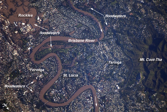 |
| Flooding in Brisbane Suburbs This detailed astronaut photograph illustrates flooding in suburbs of the Brisbane, Australia metropolitan region. The Brisbane area experienced catastrophic flooding following unusually heavy rainfall on January 10, 2011. With surficial soils already saturated from previous rainfall events, eastward-draining surface flow caused the Brisbane River to flood--inundating an estimated 20,000 homes in suburbs of the capital city of Queensland. Other cities in Queensland have also experienced damaging floods during previous heavy rainfall events this year. The image, taken by astronauts on board the International Space Station, highlights several suburbs along the Brisbane River in the southern part of the Brisbane metropolitan area. The light-colored rooftops of residences and other structures contrast sharply with green vegetation and brown, sediment laden floodwaters. Most visible low-lying areas are inundated by floodwater, perhaps the most striking being Rocklea at image upper left. The suburb of Yeronga (image lower left) also has evident regions of flooding, as does a park and golf course located along a bend in the Brisbane River to the south of St. Lucia (image center). Flooding becomes less apparent near the higher elevations of Mt. Coot-Tha at image right. |
| Images: | All Available Images Low-Resolution 333k |
|
| Mission: | ISS026 |
|
| Roll - Frame: | E - 17421 |
|
| Geographical Name: | AUSTRALIA-Q |
|
| Features: | BRISBANE RIVER,FLOODING,YERONGA,TARINGA,MOUNT COOT-THA |
|
| Center Lat x Lon: | 27.5S x 153.0E |
|
| Film Exposure: | N=Normal exposure, U=Under exposed, O=Over exposed, F=out of Focus |
|
| Percentage of Cloud Cover-CLDP: | 10 |
|
| Camera:: | N2 |
|
| Camera Tilt: | 27 | LO=Low Oblique, HO=High Oblique, NV=Near Vertical |
| Camera Focal Length: | 800 |
|
| Nadir to Photo Center Direction: | SW | The direction from the nadir to the center point, N=North, S=South, E=East, W=West |
| Stereo?: | Y=Yes there is an adjacent picture of the same area, N=No there isn't |
|
| Orbit Number: | 1660 |
|
| Date: | 20110113 | YYYYMMDD |
| Time: | 200739 | GMT HHMMSS |
| Nadir Lat: | 26.5S |
Latitude of suborbital point of spacecraft |
| Nadir Lon: | 154.3E |
Longitude of suborbital point of spacecraft |
| Sun Azimuth: | 108 | Clockwise angle in degrees from north to the sun measured at the nadir point |
| Space Craft Altitude: | 193 | nautical miles |
| Sun Elevation: | 13 | Angle in degrees between the horizon and the sun, measured at the nadir point |
| Land Views: | |
|
| Water Views: | FLOODING, RIVER, SEDIMENT |
|
| Atmosphere Views: | |
|
| Man Made Views: | |
|
| City Views: | BRISBANE |
|
Photo is not associated with any sequences | ||
| NASA Home Page |
JSC Home Page |
JSC Digital Image Collection |
Earth Science & Remote Sensing |
|
This service is provided by the International Space Station program and the JSC Earth Science & Remote Sensing Unit, ARES Division, Exploration Integration Science Directorate.

|