Geographic Region: CHINA
Feature: RONGBUK GLACIER, MOUNT CHANGTSE, MOUNT KHUMBUTSE
|
Geographic Region: CHINA Feature: RONGBUK GLACIER, MOUNT CHANGTSE, MOUNT KHUMBUTSE |
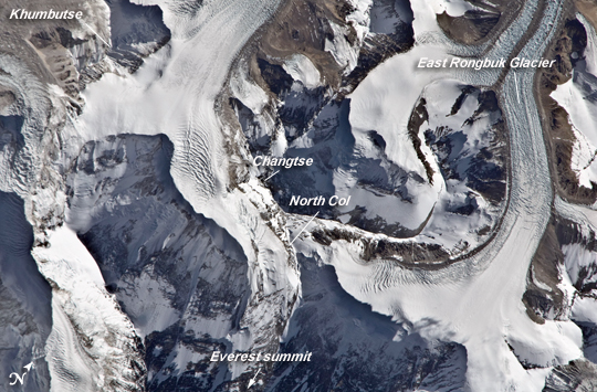 |
| North Col of Mount Everest This astronaut photograph highlights the northern approach to Mount Everest from Tibet (China). Known as the northeast ridge route, climbers travel along the East Rongbuk Glacier (image lower left) to camp at the base of Changtse mountain. From this point at approximately 6,100 meters (20,000 feet) above sea level (asl), climbers ascend the North Col--a sharp-edged pass carved by glaciers, at image center--to reach a series of progressively higher camps along the North Face of Everest. Climbers make their final push to the summit (just off the top edge of the image) from Camp VI at 8,230 meters (27,000 feet) altitude. Located within the Himalaya mountain chain, Everest (or Sagarmatha in Nepali) is the Earth's highest mountain, with its summit at 8,848 meters (29,029 feet) above sea level. Khumbutse mountain, visible at the lower right, has a summit elevation of 6,640 meters (21,785 feet) asl. While the near-nadir viewing angle--almost looking straight down from the International Space Station--tends to flatten the topography, astronauts have also taken images that highlight the rugged nature of the area. Climbing to the summit of Everest requires much advance planning, conditioning, and situational awareness on the part of mountaineers to avoid potentially fatal consequences. As of 2010, there have been over 200 reported deaths. The numerous expeditions to reach the summit of Everest have produced significant trash and spent oxygen bottles at the various camps, leading the Nepalese government to impose rules requiring climbers to return with their gear and rubbish. Several "cleanup" expeditions have removed tons of material, including the remains of several climbers. |
| Images: | All Available Images Low-Resolution 248k |
|
| Mission: | ISS026 |
|
| Roll - Frame: | E - 15208 |
|
| Geographical Name: | CHINA |
|
| Features: | RONGBUK GLACIER, MOUNT CHANGTSE, MOUNT KHUMBUTSE |
|
| Center Lat x Lon: | 28.0N x 86.9E |
|
| Film Exposure: | N=Normal exposure, U=Under exposed, O=Over exposed, F=out of Focus |
|
| Percentage of Cloud Cover-CLDP: | 10 |
|
| Camera:: | N2 |
|
| Camera Tilt: | 16 | LO=Low Oblique, HO=High Oblique, NV=Near Vertical |
| Camera Focal Length: | 800 |
|
| Nadir to Photo Center Direction: | S | The direction from the nadir to the center point, N=North, S=South, E=East, W=West |
| Stereo?: | Y=Yes there is an adjacent picture of the same area, N=No there isn't |
|
| Orbit Number: | 1542 |
|
| Date: | 20110106 | YYYYMMDD |
| Time: | 065705 | GMT HHMMSS |
| Nadir Lat: | 28.9N |
Latitude of suborbital point of spacecraft |
| Nadir Lon: | 86.8E |
Longitude of suborbital point of spacecraft |
| Sun Azimuth: | 191 | Clockwise angle in degrees from north to the sun measured at the nadir point |
| Space Craft Altitude: | 187 | nautical miles |
| Sun Elevation: | 38 | Angle in degrees between the horizon and the sun, measured at the nadir point |
| Land Views: | GLACIER, MOUNTAIN |
|
| Water Views: | |
|
| Atmosphere Views: | |
|
| Man Made Views: | |
|
| City Views: | |
|
Photo is not associated with any sequences | ||
| NASA Home Page |
JSC Home Page |
JSC Digital Image Collection |
Earth Science & Remote Sensing |
|
This service is provided by the International Space Station program and the JSC Earth Science & Remote Sensing Unit, ARES Division, Exploration Integration Science Directorate.

|