
Geographic Region: CANADA-Q
Feature: MONTREAL AT NIGHT
|
Geographic Region: CANADA-Q Feature: MONTREAL AT NIGHT |
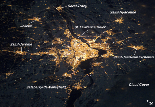 |
| Montreal at Night Note: This caption refers to the image versions labeled "NASA's Earth Observatory web site". As this image was taken by an astronaut in an upside-down orientation relative to the look direction of the camera, the Earth Observatory images have been rotated 180 degrees in order to visually agree with the known ISS ground track location at the time of image acquisition. Montreal, the largest city in the mostly French-speaking Province of Quebec, is considered by some to be the cultural capital of Canada. The metropolitan area (image center) is the country's second-largest, having been surpassed by Toronto in 1976. While the city of Montreal is located on the Island of Montreal, at the confluence of the St. Lawrence (image center) and Ottawa rivers (not visible), the city takes its name from Mont Royal, located at the city's center. Several smaller urban areas form a loose ring around the metropolitan area: Sorel-Tracy, Saint-Hyacinthe, Saint-Jean-sur-Richelieu, Salaberry-de-Valleyfield, Saint-Jerome, and Joliette are among those that can be readily identified. This astronaut photograph of the city lights of Montreal illustrates the extent of urbanization. Major roadways and industrial areas are traced by bright white lighting, while the adjacent residential and commercial lands are characterized by more diffuse yellow-gold lighting. Rivers and other water bodies appear black, while the surrounding countryside is faintly illuminated by moonlight. Blurry areas at image top and bottom right are caused by cloud cover. The International Space Station was located over the Pennsylvania-New York border (near Warren, Pa.) at the time this image was taken--a ground distance of approximately 600 kilometers (370 miles) southwest of Montreal. This distance from the camera target, coupled with the oblique (inclined) viewing angle from the ISS, results in the foreshortened appearance of urban areas in the image. |
| Images: | All Available Images Low-Resolution 276k |
|
| Mission: | ISS026 |
|
| Roll - Frame: | E - 12474 |
|
| Geographical Name: | CANADA-Q |
|
| Features: | MONTREAL AT NIGHT |
|
| Center Lat x Lon: | 45.5N x 73.8W |
|
| Film Exposure: | N=Normal exposure, U=Under exposed, O=Over exposed, F=out of Focus |
|
| Percentage of Cloud Cover-CLDP: | 10 |
|
| Camera:: | N5 |
|
| Camera Tilt: | HO | LO=Low Oblique, HO=High Oblique, NV=Near Vertical |
| Camera Focal Length: | 180 |
|
| Nadir to Photo Center Direction: | NE | The direction from the nadir to the center point, N=North, S=South, E=East, W=West |
| Stereo?: | Y=Yes there is an adjacent picture of the same area, N=No there isn't |
|
| Orbit Number: | 1337 |
|
| Date: | 20101224 | YYYYMMDD |
| Time: | 063614 | GMT HHMMSS |
| Nadir Lat: | 41.9N |
Latitude of suborbital point of spacecraft |
| Nadir Lon: | 79.1W |
Longitude of suborbital point of spacecraft |
| Sun Azimuth: | 49 | Clockwise angle in degrees from north to the sun measured at the nadir point |
| Space Craft Altitude: | 187 | nautical miles |
| Sun Elevation: | -65 | Angle in degrees between the horizon and the sun, measured at the nadir point |
| Land Views: | |
|
| Water Views: | |
|
| Atmosphere Views: | |
|
| Man Made Views: | |
|
| City Views: | MONTREAL, |
|
Photo is not associated with any sequences | ||
| NASA Home Page |
JSC Home Page |
JSC Digital Image Collection |
Earth Science & Remote Sensing |
|
This service is provided by the International Space Station program and the JSC Earth Science & Remote Sensing Unit, ARES Division, Exploration Integration Science Directorate.

|