Geographic Region: CHINA
Feature: BEIJING,LANGFANG,TIANJIN AT NIGHT
|
Geographic Region: CHINA Feature: BEIJING,LANGFANG,TIANJIN AT NIGHT |
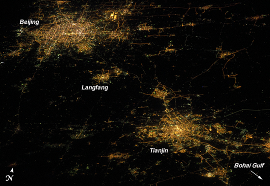 |
| Cities at Night, Northern China Note: This caption refers to the image versions labeled "NASA's Earth Observatory web site". Nighttime images have a way of dramatically revealing the amount of land development in metropolitan areas. This astronaut photograph features two of China's most populous cities--Beijing and Tianjin--both in the northeastern part of the country near the Bohai Gulf. The United Nations estimated the 2010 population of the Beijing metropolitan area to be approximately 12 million, with the population of Tianjin estimated at more than 7 million. The smaller city of Langfang, located midway between Beijing and Tianjin, is also clearly visible, as are several smaller developments to the northeast. The dark regions are mainly agricultural fields, with wheat and corn being the major crops. Beijing (also known as Peking) is one of the ancient capital cities and the current capital of the People's Republic of China. Its regular grid pattern is clearly visible at image upper left; concentric rings of major roadways around the city have been added as the metropolitan area has expanded. Tianjin is a major trade center linked to seaports on the Bohai Gulf. The city lies along the Grand Canal of China, a major artificial waterway extending southward for 1,176 kilometers (1,103 miles) from Beijing to Hangzhou. This photograph was acquired by astronauts on the International Space Station (ISS) when it was located approximately 630 kilometers (391 miles) away, over the Yellow Sea near the western coastline of North Korea. The flattened perspective of the urban areas is the result of the viewing angle and distance from the ISS. The city light patterns are very clear, indicating that there was little cloud cover or haze in the region at the time. |
| Images: | All Available Images Low-Resolution 228k |
|
| Mission: | ISS026 |
|
| Roll - Frame: | E - 10155 |
|
| Geographical Name: | CHINA |
|
| Features: | BEIJING,LANGFANG,TIANJIN AT NIGHT |
|
| Center Lat x Lon: | 39.4N x 116.8E |
|
| Film Exposure: | N=Normal exposure, U=Under exposed, O=Over exposed, F=out of Focus |
|
| Percentage of Cloud Cover-CLDP: | 10 |
|
| Camera:: | N5 |
|
| Camera Tilt: | HO | LO=Low Oblique, HO=High Oblique, NV=Near Vertical |
| Camera Focal Length: | 180 |
|
| Nadir to Photo Center Direction: | W | The direction from the nadir to the center point, N=North, S=South, E=East, W=West |
| Stereo?: | Y=Yes there is an adjacent picture of the same area, N=No there isn't |
|
| Orbit Number: | 1185 |
|
| Date: | 20101214 | YYYYMMDD |
| Time: | 143442 | GMT HHMMSS |
| Nadir Lat: | 38.5N |
Latitude of suborbital point of spacecraft |
| Nadir Lon: | 124.0E |
Longitude of suborbital point of spacecraft |
| Sun Azimuth: | 313 | Clockwise angle in degrees from north to the sun measured at the nadir point |
| Space Craft Altitude: | 185 | nautical miles |
| Sun Elevation: | -70 | Angle in degrees between the horizon and the sun, measured at the nadir point |
| Land Views: | |
|
| Water Views: | |
|
| Atmosphere Views: | |
|
| Man Made Views: | |
|
| City Views: | BEIJING, TIANJIN |
|
Photo is not associated with any sequences | ||
| NASA Home Page |
JSC Home Page |
JSC Digital Image Collection |
Earth Science & Remote Sensing |
|
This service is provided by the International Space Station program and the JSC Earth Science & Remote Sensing Unit, ARES Division, Exploration Integration Science Directorate.

|