
Geographic Region: USA-MONTANA
Feature: WILLOW MOUNTAIN, DOMINIC POINT FIRE, SMOKE PLUME
|
Geographic Region: USA-MONTANA Feature: WILLOW MOUNTAIN, DOMINIC POINT FIRE, SMOKE PLUME |
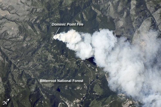 |
| Dominic Point Fire, Montana Lightning strikes and human activities in the forested mountains of the western United States can spark wildfires during the summer dry season. The Dominic Point Fire was first reported near 3:00 p.m. local time on Sunday, July 25, 2010. Approximately one hour later, the International Space Station crew photographed the fire's large smoke plume--already extending at least 8 kilometers (5 miles) to the east--from orbit as the station passed almost directly overhead. Forest Service fire crews, slurry bombers, and helicopters were on the scene by that evening. The fire may have been started by a lightning strike, as there are no trails leading into the fire area located approximately 22 kilometers (14 miles) northeast of Hamilton, Montana, according to local reports. As of July 26, 2010, the fire had burned approximately 700 to 1,000 acres (283 to 405 hectares) of the Bitterroot National Forest in western Montana. The fire is thought to have expanded quickly due to high temperatures, low humidity, and favorable winds with an abundance of deadfall--dead trees and logs that provide readily combustible fuels--in the area. |
| Images: | All Available Images Low-Resolution 223k |
|
| Mission: | ISS024 |
|
| Roll - Frame: | E - 9526 |
|
| Geographical Name: | USA-MONTANA |
|
| Features: | WILLOW MOUNTAIN, DOMINIC POINT FIRE, SMOKE PLUME |
|
| Center Lat x Lon: | 46.3N x 113.9W |
|
| Film Exposure: | N=Normal exposure, U=Under exposed, O=Over exposed, F=out of Focus |
|
| Percentage of Cloud Cover-CLDP: | 10 |
|
| Camera:: | N4 |
|
| Camera Tilt: | 14 | LO=Low Oblique, HO=High Oblique, NV=Near Vertical |
| Camera Focal Length: | 100 |
|
| Nadir to Photo Center Direction: | N | The direction from the nadir to the center point, N=North, S=South, E=East, W=West |
| Stereo?: | Y=Yes there is an adjacent picture of the same area, N=No there isn't |
|
| Orbit Number: | 2956 |
|
| Date: | 20100725 | YYYYMMDD |
| Time: | 215757 | GMT HHMMSS |
| Nadir Lat: | 45.6N |
Latitude of suborbital point of spacecraft |
| Nadir Lon: | 114.2W |
Longitude of suborbital point of spacecraft |
| Sun Azimuth: | 238 | Clockwise angle in degrees from north to the sun measured at the nadir point |
| Space Craft Altitude: | 186 | nautical miles |
| Sun Elevation: | 52 | Angle in degrees between the horizon and the sun, measured at the nadir point |
| Land Views: | FOREST |
|
| Water Views: | |
|
| Atmosphere Views: | PLUME, SMOKE |
|
| Man Made Views: | |
|
| City Views: | |
|
Photo is not associated with any sequences | ||
| NASA Home Page |
JSC Home Page |
JSC Digital Image Collection |
Earth Science & Remote Sensing |
|
This service is provided by the International Space Station program and the JSC Earth Science & Remote Sensing Unit, ARES Division, Exploration Integration Science Directorate.

|