
Geographic Region: PERU
Feature: SABANCAYA VOLCANO,LAVA FLOWS,AMPATO VOLCANO,HUALCA HUALCA VOLCANO
|
Geographic Region: PERU Feature: SABANCAYA VOLCANO,LAVA FLOWS,AMPATO VOLCANO,HUALCA HUALCA VOLCANO |
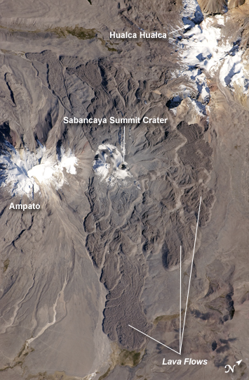 |
| Sabancaya Volcano, Peru The 5,967-meter- (19,577-foot-) high Sabancaya stratovolcano (Nevado Sabancaya in the local language) is located in southern Peru, approximately 70 kilometers (40 miles) northwest of the city of Arequipa. The name Sabancaya means "tongue of fire" in the Quechua Indian language. Sabancaya is part of a volcanic complex that includes two other nearby (and older) volcanoes, neither of which has been active historically. In this detailed astronaut photograph, Nevado Ampato is visible to the south (image left), and the lower flanks of Nevado Hualca Hualca are visible to the north (image top right). The snowy peaks of the three volcanoes provide a stark contrast to the surrounding desert of the Puna Plateau. Sabancaya's first historical record of an eruption dates to 1750. The most recent eruptive activity at the volcano occurred in July 2003, and it deposited ash on the volcano's summit and northeastern flank. Volcanism at Sabancaya is fueled by magma generated at the subduction zone between the Nazca and South American tectonic plates. Magma can erupt to the surface and form lava flows through the volcano's summit (frequently forming a crater), but it can also erupt from lava domes and flank vents along the volcano's sides. Lava has issued from all of these points at Sabancaya, forming numerous gray to dark brown scalloped lobes that extend in all directions except southwards (image center). |
| Images: | All Available Images Low-Resolution 221k |
|
| Mission: | ISS024 |
|
| Roll - Frame: | E - 8396 |
|
| Geographical Name: | PERU |
|
| Features: | SABANCAYA VOLCANO,LAVA FLOWS,AMPATO VOLCANO,HUALCA HUALCA VOLCANO |
|
| Center Lat x Lon: | 15.8S x 71.8W |
|
| Film Exposure: | N=Normal exposure, U=Under exposed, O=Over exposed, F=out of Focus |
|
| Percentage of Cloud Cover-CLDP: | 10 |
|
| Camera:: | N2 |
|
| Camera Tilt: | 17 | LO=Low Oblique, HO=High Oblique, NV=Near Vertical |
| Camera Focal Length: | 400 |
|
| Nadir to Photo Center Direction: | E | The direction from the nadir to the center point, N=North, S=South, E=East, W=West |
| Stereo?: | Y=Yes there is an adjacent picture of the same area, N=No there isn't |
|
| Orbit Number: | 2793 |
|
| Date: | 20100715 | YYYYMMDD |
| Time: | 140740 | GMT HHMMSS |
| Nadir Lat: | 15.7S |
Latitude of suborbital point of spacecraft |
| Nadir Lon: | 72.8W |
Longitude of suborbital point of spacecraft |
| Sun Azimuth: | 49 | Clockwise angle in degrees from north to the sun measured at the nadir point |
| Space Craft Altitude: | 192 | nautical miles |
| Sun Elevation: | 34 | Angle in degrees between the horizon and the sun, measured at the nadir point |
| Land Views: | CRATER, DESERT, PLATEAU, VOLCANO |
|
| Water Views: | |
|
| Atmosphere Views: | |
|
| Man Made Views: | |
|
| City Views: | |
|
Photo is not associated with any sequences | ||
| NASA Home Page |
JSC Home Page |
JSC Digital Image Collection |
Earth Science & Remote Sensing |
|
This service is provided by the International Space Station program and the JSC Earth Science & Remote Sensing Unit, ARES Division, Exploration Integration Science Directorate.

|