
Geographic Region: RUSSIAN FEDERATION
Feature: CASPIAN SEA,VOLGA RIVER DELTA,URAL RIVER DELTA,SMOKE PLUME,SUNGLINT
|
Geographic Region: RUSSIAN FEDERATION Feature: CASPIAN SEA,VOLGA RIVER DELTA,URAL RIVER DELTA,SMOKE PLUME,SUNGLINT |
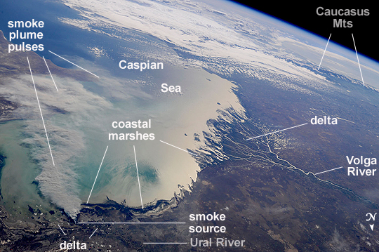 |
| This broad view of the north coast of the Caspian Sea shows a smoke plume (image left) and two river deltas (image bottom and lower right). The larger delta is that of the Volga River which appears prominently here in sunglint (light reflected off a water surface back towards the observer), and the smaller less prominent delta is that of the Ural River. Wide angle, oblique views - taken looking outward at an angle, rather than straight down towards the Earth - such as this give an excellent impression of how astronauts onboard the International Space Station view the Earth. For a sense of scale, the Caucasus Mts. (across the Caspian , image top right) are approximately 1100 km to the southwest of the International Space Station's nadir point location - the point on the Earth directly underneath the spacecraft - at the time this image was taken. The smoke plume appears to be sourced in the dark-toned coastal marsh vegetation along the outer fringe of the Ural River delta, rather than in a city or at some oil storage facility. Although even small fires produce plumes that are long and bright and thus easily visible from space, the density of the smoke in this plume, and its 350-km length across the entire north lobe of the Caspian Sea, suggest it was a significant fire. The smoke was thick enough nearer the source to cast shadows on the sea surface below. Lines mark three separate pulses of smoke, the most recent, nearest the source, extending directly south away from the coastline (image lower left). With time, plumes become progressively more diffuse. The oldest pulse appears to be the thinnest, casting no obvious shadows (image center left). |
| Images: | All Available Images Low-Resolution 281k |
|
| Mission: | ISS024 |
|
| Roll - Frame: | E - 14233 |
|
| Geographical Name: | RUSSIAN FEDERATION |
|
| Features: | CASPIAN SEA,VOLGA RIVER DELTA,URAL RIVER DELTA,SMOKE PLUME,SUNGLINT |
|
| Center Lat x Lon: | 45.5N x 48.5E |
|
| Film Exposure: | N=Normal exposure, U=Under exposed, O=Over exposed, F=out of Focus |
|
| Percentage of Cloud Cover-CLDP: | 25 |
|
| Camera:: | N4 |
|
| Camera Tilt: | HO | LO=Low Oblique, HO=High Oblique, NV=Near Vertical |
| Camera Focal Length: | 50 |
|
| Nadir to Photo Center Direction: | SW | The direction from the nadir to the center point, N=North, S=South, E=East, W=West |
| Stereo?: | Y=Yes there is an adjacent picture of the same area, N=No there isn't |
|
| Orbit Number: | 3704 |
|
| Date: | 20100911 | YYYYMMDD |
| Time: | 112410 | GMT HHMMSS |
| Nadir Lat: | 49.6N |
Latitude of suborbital point of spacecraft |
| Nadir Lon: | 55.4E |
Longitude of suborbital point of spacecraft |
| Sun Azimuth: | 238 | Clockwise angle in degrees from north to the sun measured at the nadir point |
| Space Craft Altitude: | 187 | nautical miles |
| Sun Elevation: | 30 | Angle in degrees between the horizon and the sun, measured at the nadir point |
| Land Views: | COAST |
|
| Water Views: | DELTA, RIVER, SEA, SUNGLINT |
|
| Atmosphere Views: | PLUME, SMOKE |
|
| Man Made Views: | |
|
| City Views: | |
|
Photo is not associated with any sequences | ||
| NASA Home Page |
JSC Home Page |
JSC Digital Image Collection |
Earth Science & Remote Sensing |
|
This service is provided by the International Space Station program and the JSC Earth Science & Remote Sensing Unit, ARES Division, Exploration Integration Science Directorate.

|