
Geographic Region: SYRIA
Feature: ES SAFA VOLCANIC FIELD
|
Geographic Region: SYRIA Feature: ES SAFA VOLCANIC FIELD |
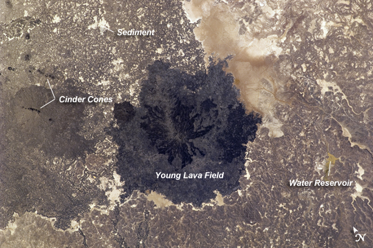 |
| Es Safa Volcanic Field, Syria Es Safa is a striking basaltic volcanic field located to the southeast of Damascus, Syria. It lies within the larger Harrat Ash Shamah--the largest volcanic field on the Arabian tectonic plate. Harrat Ash Shamah parallels the Red Sea and extends from northeastern Israel, through southern Syria and Jordan, and into Saudi Arabia, covering an area of over 50,000 square kilometers (19,000 square miles). Es Safa contains numerous vents that have been active during the Holocene Epoch (beginning approximately 12,000 years ago). The most recent recorded activity was a boiling lava lake observed in the area around 1850. The dark lava flow field (center) likely represents the latest activity of the volcanic field, and is emplaced over older, lighter colored flows. The older flow surfaces also have light tan sediment accumulating in shallow depressions, in contrast to the relatively pristine surfaces of the darker, younger flows. Cinder cones are scattered throughout the Es Safa field, but many are aligned along northwest-southeast trends that likely indicate faults through which magma rose to the surface. Two such alignments are visible at image left. To the southeast (image right) a small reservoir feeds water distribution ditches extending northwards. |
| Images: | All Available Images Low-Resolution 277k |
|
| Mission: | ISS024 |
|
| Roll - Frame: | E - 13690 |
|
| Geographical Name: | SYRIA |
|
| Features: | ES SAFA VOLCANIC FIELD |
|
| Center Lat x Lon: | 33.0N x 37.2E |
|
| Film Exposure: | N=Normal exposure, U=Under exposed, O=Over exposed, F=out of Focus |
|
| Percentage of Cloud Cover-CLDP: | 10 |
|
| Camera:: | N2 |
|
| Camera Tilt: | 9 | LO=Low Oblique, HO=High Oblique, NV=Near Vertical |
| Camera Focal Length: | 180 |
|
| Nadir to Photo Center Direction: | NW | The direction from the nadir to the center point, N=North, S=South, E=East, W=West |
| Stereo?: | Y=Yes there is an adjacent picture of the same area, N=No there isn't |
|
| Orbit Number: | 3595 |
|
| Date: | 20100904 | YYYYMMDD |
| Time: | 125509 | GMT HHMMSS |
| Nadir Lat: | 32.7N |
Latitude of suborbital point of spacecraft |
| Nadir Lon: | 37.6E |
Longitude of suborbital point of spacecraft |
| Sun Azimuth: | 254 | Clockwise angle in degrees from north to the sun measured at the nadir point |
| Space Craft Altitude: | 188 | nautical miles |
| Sun Elevation: | 36 | Angle in degrees between the horizon and the sun, measured at the nadir point |
| Land Views: | |
|
| Water Views: | RESERVOIR, SEDIMENT |
|
| Atmosphere Views: | |
|
| Man Made Views: | |
|
| City Views: | |
|
Photo is not associated with any sequences | ||
| NASA Home Page |
JSC Home Page |
JSC Digital Image Collection |
Earth Science & Remote Sensing |
|
This service is provided by the International Space Station program and the JSC Earth Science & Remote Sensing Unit, ARES Division, Exploration Integration Science Directorate.

|