Geographic Region: LESOTHO
Feature: MASERU, LADYBRAND, CALEDON RIVER, AGR., DISSECTED PLATEAU
|
Geographic Region: LESOTHO Feature: MASERU, LADYBRAND, CALEDON RIVER, AGR., DISSECTED PLATEAU |
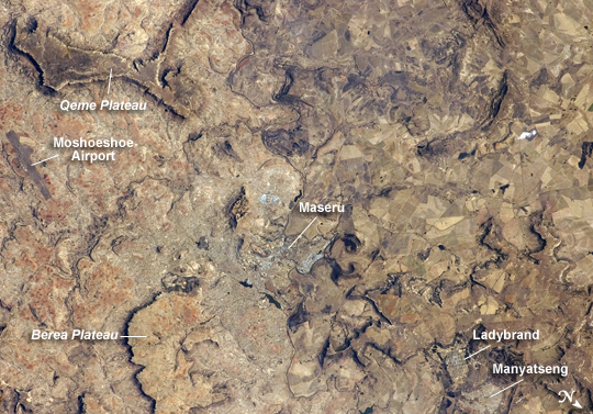 |
| Maseru, Lesotho Maseru is the capital city of the Kingdom of Lesotho, and is located along the northwestern border of the country with the Republic of South Africa. The footprint of the urban area, recognizable by street grids and distinctive blue-roofed industrial buildings at image center, is only just visible against the surrounding landscape. The city has expanded eightfold (population 230,000 today) since independence from the United Kingdom of Great Britain and Northern Ireland in 1966, and is now home to one in five citizens of the country. The Caledon (or Mohokare) River flows adjacent to Maseru and forms a part of the border between Lesotho and South Africa. Locally, the border extends from approximately image top center left to image bottom center right, with the cities of Ladybrand and Manyatseng located in South Africa. Moshoeshoe International Airport (left) provides access to the capital. Major industries in the city include flour mills and footwear and textile companies. Tourism is also a growing part of the local economy. The Kingdom of Lesotho is completely landlocked by the surrounding Republic of South Africa. Major landforms visible in the image include the Qeme and Berea Plateaus, erosional remnants of horizontally layered sedimentary rocks that formed in the Karoo Basin approximately 200 - 229 million years ago during the Upper Triassic Period. |
| Images: | All Available Images Low-Resolution 314k |
|
| Mission: | ISS024 |
|
| Roll - Frame: | E - 12749 |
|
| Geographical Name: | LESOTHO |
|
| Features: | MASERU, LADYBRAND, CALEDON RIVER, AGR., DISSECTED PLATEAU |
|
| Center Lat x Lon: | 29.3S x 27.5E |
|
| Film Exposure: | N=Normal exposure, U=Under exposed, O=Over exposed, F=out of Focus |
|
| Percentage of Cloud Cover-CLDP: | 10 |
|
| Camera:: | N2 |
|
| Camera Tilt: | 11 | LO=Low Oblique, HO=High Oblique, NV=Near Vertical |
| Camera Focal Length: | 180 |
|
| Nadir to Photo Center Direction: | SW | The direction from the nadir to the center point, N=North, S=South, E=East, W=West |
| Stereo?: | Y=Yes there is an adjacent picture of the same area, N=No there isn't |
|
| Orbit Number: | 3484 |
|
| Date: | 20100828 | YYYYMMDD |
| Time: | 124109 | GMT HHMMSS |
| Nadir Lat: | 28.8S |
Latitude of suborbital point of spacecraft |
| Nadir Lon: | 27.9E |
Longitude of suborbital point of spacecraft |
| Sun Azimuth: | 311 | Clockwise angle in degrees from north to the sun measured at the nadir point |
| Space Craft Altitude: | 191 | nautical miles |
| Sun Elevation: | 37 | Angle in degrees between the horizon and the sun, measured at the nadir point |
| Land Views: | BASIN |
|
| Water Views: | RIVER |
|
| Atmosphere Views: | |
|
| Man Made Views: | AIRPORT, URBAN AREA |
|
| City Views: | MASERU |
|
Photo is not associated with any sequences | ||
| NASA Home Page |
JSC Home Page |
JSC Digital Image Collection |
Earth Science & Remote Sensing |
|
This service is provided by the International Space Station program and the JSC Earth Science & Remote Sensing Unit, ARES Division, Exploration Integration Science Directorate.

|