Geographic Region: TUAMOTU ARCHIPELAGO
Feature: MATAIVA ISLAND,CORAL REEF,PACIFIC OCEAN,PAHUA
|
Geographic Region: TUAMOTU ARCHIPELAGO Feature: MATAIVA ISLAND,CORAL REEF,PACIFIC OCEAN,PAHUA |
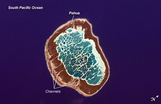 |
| Mataiva Atoll, Tuamotu Archipelago, South Pacific Ocean The Tuamotu Archipelago is part of French Polynesia, and forms the largest chain of atolls in the world. This astronaut photograph features Mataiva Atoll, the westernmost atoll of the Tuamotu chain. An atoll is a ring-shaped island that encloses a central lagoon. This distinctive morphology is usually associated with oceanic islands formed by volcanoes; coral reefs become established around the partially submerged volcanic cone. Over geologic time the central volcano becomes extinct, followed by erosion and subsidence beneath the sea surface, leaving the coral reefs as a ring around (or cap on) the submerged island remnant. Coral reefs exposed above the sea surface in turn experience erosion, sedimentation, and soil formation, leading to the establishment of vegetation and complex ecosystems--including in many cases human habitation. Mataiva Atoll is notable in that its central lagoon includes a network of ridges (white, image center) and small basins formed from eroded coral reefs. Mataiva means "nine eyes" in Tuamotuan, an allusion to nine narrow channels on the south-central portion of the island. The atoll is sparsely populated, with only a single village--Pahua--located on either side of the only pass providing constant connection between the shallow (light blue) water of the lagoon and the deeper (dark blue) adjacent Pacific Ocean. Much of the 10-kilometer- (6-mile-) long atoll is covered with forest (greenish brown). Vanilla and copra (dried coconut) are major exports from the atoll, but tourism is becoming a larger part of the economy. |
| Images: | All Available Images Low-Resolution 181k |
|
| Mission: | ISS024 |
|
| Roll - Frame: | E - 11914 |
|
| Geographical Name: | TUAMOTU ARCHIPELAGO |
|
| Features: | MATAIVA ISLAND,CORAL REEF,PACIFIC OCEAN,PAHUA |
|
| Center Lat x Lon: | 14.9S x 148.7W |
|
| Film Exposure: | N=Normal exposure, U=Under exposed, O=Over exposed, F=out of Focus |
|
| Percentage of Cloud Cover-CLDP: | 10 |
|
| Camera:: | N2 |
|
| Camera Tilt: | 46 | LO=Low Oblique, HO=High Oblique, NV=Near Vertical |
| Camera Focal Length: | 400 |
|
| Nadir to Photo Center Direction: | E | The direction from the nadir to the center point, N=North, S=South, E=East, W=West |
| Stereo?: | Y=Yes there is an adjacent picture of the same area, N=No there isn't |
|
| Orbit Number: | 3254 |
|
| Date: | 20100813 | YYYYMMDD |
| Time: | 210718 | GMT HHMMSS |
| Nadir Lat: | 14.5S |
Latitude of suborbital point of spacecraft |
| Nadir Lon: | 151.9W |
Longitude of suborbital point of spacecraft |
| Sun Azimuth: | 30 | Clockwise angle in degrees from north to the sun measured at the nadir point |
| Space Craft Altitude: | 190 | nautical miles |
| Sun Elevation: | 57 | Angle in degrees between the horizon and the sun, measured at the nadir point |
| Land Views: | ATOLL, EROSION, FOREST, ISLAND, VOLCANO |
|
| Water Views: | LAGOON, OCEAN, SEA |
|
| Atmosphere Views: | |
|
| Man Made Views: | |
|
| City Views: | |
|
Photo is not associated with any sequences | ||
| NASA Home Page |
JSC Home Page |
JSC Digital Image Collection |
Earth Science & Remote Sensing |
|
This service is provided by the International Space Station program and the JSC Earth Science & Remote Sensing Unit, ARES Division, Exploration Integration Science Directorate.

|