
Geographic Region: USA-TEXAS
Feature: JOHNSON SPACE CENTER, CLEAR LAKE, WEBSTER,GALVESTON BAY,SEABROOK,SUNGLINT
|
Geographic Region: USA-TEXAS Feature: JOHNSON SPACE CENTER, CLEAR LAKE, WEBSTER,GALVESTON BAY,SEABROOK,SUNGLINT |
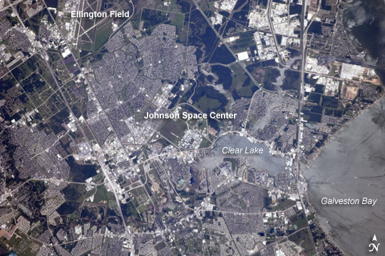 |
| NASA Johnson Space Center, Houston, TX This detailed astronaut photograph is centered on the NASA Lyndon B. Johnson Space Center (JSC), located in the southeastern Houston metropolitan area. The facility was established in 1961 as the Manned Spacecraft Center and renamed in honor of the late U.S. President Johnson (a Texas native) in 1973. JSC serves as the lead NASA center for both astronaut training and mission control of manned spacecraft--such as the International Space Station (ISS) and Space Shuttle--and has done so throughout the history of the U.S. manned space program. The Center also collaborates with other NASA and international partner facilities in a variety of scientific and engineering programs related to human space flight and planetary exploration. JSC is located approximately midway between downtown Houston and Galveston, and is bordered by several smaller municipalities that form a mosaic of urban and suburban land use (grey areas with street grids, and commercial/industrial areas characterized by white rooftops). Large tracts of grassy fields and forests in the area (light to dark green respectively) include nature preserves, grazing lands, and flood control areas. Also visible at image upper left is Ellington Field. This airport services a variety of NASA aircraft used for astronaut training, scientific, and cargo transport purposes. Clear Lake, an inlet of Galveston Bay, is located to the immediate southeast of JSC. Both Clear Lake and Galveston Bay appear silver-grey due to sunglint, or light reflected back towards the observer on the ISS that gives the water surface a mirror-like appearance. Several boat wakes are visible in Galveston Bay (image right) due to disruption of the water surface that reduces the sunglint effect. Other astronaut photographs also feature the Houston and Galveston Bay area, including images of Houston at Night and the Houston Ship Channel area. |
| Images: | All Available Images Low-Resolution 270k |
|
| Mission: | ISS024 |
|
| Roll - Frame: | E - 10403 |
|
| Geographical Name: | USA-TEXAS |
|
| Features: | JOHNSON SPACE CENTER, CLEAR LAKE, WEBSTER,GALVESTON BAY,SEABROOK,SUNGLINT |
|
| Center Lat x Lon: | 29.6N x 95.1W |
|
| Film Exposure: | N=Normal exposure, U=Under exposed, O=Over exposed, F=out of Focus |
|
| Percentage of Cloud Cover-CLDP: | 10 |
|
| Camera:: | N2 |
|
| Camera Tilt: | 18 | LO=Low Oblique, HO=High Oblique, NV=Near Vertical |
| Camera Focal Length: | 400 |
|
| Nadir to Photo Center Direction: | S | The direction from the nadir to the center point, N=North, S=South, E=East, W=West |
| Stereo?: | Y=Yes there is an adjacent picture of the same area, N=No there isn't |
|
| Orbit Number: | 3049 |
|
| Date: | 20100731 | YYYYMMDD |
| Time: | 200123 | GMT HHMMSS |
| Nadir Lat: | 30.6N |
Latitude of suborbital point of spacecraft |
| Nadir Lon: | 95.3W |
Longitude of suborbital point of spacecraft |
| Sun Azimuth: | 245 | Clockwise angle in degrees from north to the sun measured at the nadir point |
| Space Craft Altitude: | 187 | nautical miles |
| Sun Elevation: | 65 | Angle in degrees between the horizon and the sun, measured at the nadir point |
| Land Views: | |
|
| Water Views: | BAY, INLET, LAKE, SUNGLINT |
|
| Atmosphere Views: | |
|
| Man Made Views: | AIRPORT |
|
| City Views: | HOUSTON |
|
Photo is not associated with any sequences | ||
| NASA Home Page |
JSC Home Page |
JSC Digital Image Collection |
Earth Science & Remote Sensing |
|
This service is provided by the International Space Station program and the JSC Earth Science & Remote Sensing Unit, ARES Division, Exploration Integration Science Directorate.

|