 Photo #: ISS023-E-57948 Date: May 2010
Geographic Region: INDIAN OCEAN
Feature: ATMOSPHERIC LIMB,CLOUDS,SKYGLOW
|
Photo #: ISS023-E-57948 Date: May 2010 Geographic Region: INDIAN OCEAN Feature: ATMOSPHERIC LIMB,CLOUDS,SKYGLOW |
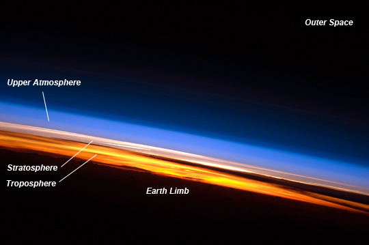 |
| Sunset Seen from the International Space Station This spectacular image of sunset on the Indian Ocean was taken by astronauts aboard the International Space Station (ISS). The image presents an edge-on, or limb view, of the Earth's atmosphere as seen from orbit. The Earth's curvature is visible along the horizon line, or limb, that extends across the image from center left to lower right. Above the darkened surface of the Earth, a brilliant sequence of colors roughly denotes several layers of the atmosphere. Deep oranges and yellows appear in the troposphere, which extends from the Earth's surface to 6-20 km high. This layer contains over 80 percent of the mass of the atmosphere and almost all of the water vapor, clouds, and precipitation. Several dark cloud layers are visible within this layer. Variations in the colors are due mainly to varying concentrations of either clouds or aerosols (airborne particles or droplets). The pink to white region above the clouds appears to be the lower stratosphere; this atmospheric layer generally has few or no clouds, and it extends up to approximately 50 km above the Earth's surface. Above the stratosphere, blue layers likely mark the transition between the middle and upper atmosphere as it gradually fades into the blackness of outer space. The ISS was located over the southern Indian Ocean when this picture was taken, with the astronaut looking towards the west. Astronauts aboard the ISS see 16 sunrises and sunsets per day due to their high orbital velocity (greater than 28,000 km per hour). The multiple chances for photography are fortunate because at that speed, each sunrise or sunset only lasts a few seconds! |
| Images: | All Available Images Low-Resolution 116k |
|
| Mission: | ISS023 |
|
| Roll - Frame: | E - 57948 |
|
| Geographical Name: | INDIAN OCEAN |
|
| Features: | ATMOSPHERIC LIMB,CLOUDS,SKYGLOW |
|
| Center Lat x Lon: | N x E |
|
| Film Exposure: | N=Normal exposure, U=Under exposed, O=Over exposed, F=out of Focus |
|
| Percentage of Cloud Cover-CLDP: | 75 |
|
| Camera:: | N3 |
|
| Camera Tilt: | HO | LO=Low Oblique, HO=High Oblique, NV=Near Vertical |
| Camera Focal Length: | 400 |
|
| Nadir to Photo Center Direction: | The direction from the nadir to the center point, N=North, S=South, E=East, W=West |
|
| Stereo?: | Y=Yes there is an adjacent picture of the same area, N=No there isn't |
|
| Orbit Number: | 1991 |
|
| Date: | 20100525 | YYYYMMDD |
| Time: | 142514 | GMT HHMMSS |
| Nadir Lat: | 8.9S |
Latitude of suborbital point of spacecraft |
| Nadir Lon: | 74.2E |
Longitude of suborbital point of spacecraft |
| Sun Azimuth: | 289 | Clockwise angle in degrees from north to the sun measured at the nadir point |
| Space Craft Altitude: | 192 | nautical miles |
| Sun Elevation: | -23 | Angle in degrees between the horizon and the sun, measured at the nadir point |
| Land Views: | |
|
| Water Views: | |
|
| Atmosphere Views: | |
|
| Man Made Views: | |
|
| City Views: | |
|
Photo is not associated with any sequences | ||
| NASA Home Page |
JSC Home Page |
JSC Digital Image Collection |
Earth Science & Remote Sensing |
|
This service is provided by the International Space Station program and the JSC Earth Science & Remote Sensing Unit, ARES Division, Exploration Integration Science Directorate.

|