Geographic Region: RUSSIAN FEDERATION
Feature: FUSS PEAK, PARAMUSHIR ISLAND, CHIKURACHKI VOLCANO
|
Geographic Region: RUSSIAN FEDERATION Feature: FUSS PEAK, PARAMUSHIR ISLAND, CHIKURACHKI VOLCANO |
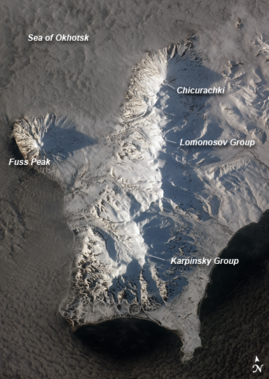 |
| Southern Paramushir Island, Kuril Chain, Russia The Kuril Island chain is built from a line of volcanoes, an island arc, that extends from Russia's Kamchatka Peninsula to northern Japan. Island arcs form along an active boundary between two tectonic plates, with one being driven beneath the other (subduction). Magma generated by subduction feeds volcanoes--and eventually volcanic islands--over the subduction boundary. Paramushir Island in the northern Kurils is an example of a large island built by several volcanoes over geologic time. This astronaut photograph shows the southern end of Paramushir Island after a snowfall. The western slopes of the mountains are brightly illuminated, while the eastern slopes are in shadow. Four major volcanic centers create this part of the island. Fuss Peak (image center left) is an isolated stratovolcano connected to the main island via an isthmus. Fuss Peak last erupted in 1854. The southern tip of the island is occupied by the Karpinsky Group of three volcanic centers. A minor eruption of ash following an earthquake occurred on this part of the island in 1952. The Lomonosov Group to the northeast (image center) includes four cinder cones and a lava dome that produced several lava flows in the past, but there have been no eruptions from the Lomonosov Group in recorded history. The most recent volcanic activity on Paramushir Island occurred in 2008 at the Chikurachki cone located along the northern coastline of the island at image top center. The summit of this volcano [1,816 meters (5,958 feet) above sea level] is the highest on Paramushir Island. Much of the Sea of Okhotsk visible in the image is covered with low clouds that often form around the islands in the Kuril chain. The clouds are generated by moisture-laden air passing over the cool sea/ocean water, and they typically wrap around the volcanic islands. |
| Images: | All Available Images Low-Resolution 216k |
|
| Mission: | ISS023 |
|
| Roll - Frame: | E - 41934 |
|
| Geographical Name: | RUSSIAN FEDERATION |
|
| Features: | FUSS PEAK, PARAMUSHIR ISLAND, CHIKURACHKI VOLCANO |
|
| Center Lat x Lon: | 50.2N x 155.4E |
|
| Film Exposure: | N=Normal exposure, U=Under exposed, O=Over exposed, F=out of Focus |
|
| Percentage of Cloud Cover-CLDP: | 50 |
|
| Camera:: | N3 |
|
| Camera Tilt: | 42 | LO=Low Oblique, HO=High Oblique, NV=Near Vertical |
| Camera Focal Length: | 280 |
|
| Nadir to Photo Center Direction: | SW | The direction from the nadir to the center point, N=North, S=South, E=East, W=West |
| Stereo?: | Y=Yes there is an adjacent picture of the same area, N=No there isn't |
|
| Orbit Number: | 1782 |
|
| Date: | 20100512 | YYYYMMDD |
| Time: | 073204 | GMT HHMMSS |
| Nadir Lat: | 51.7N |
Latitude of suborbital point of spacecraft |
| Nadir Lon: | 157.8E |
Longitude of suborbital point of spacecraft |
| Sun Azimuth: | 283 | Clockwise angle in degrees from north to the sun measured at the nadir point |
| Space Craft Altitude: | 187 | nautical miles |
| Sun Elevation: | 13 | Angle in degrees between the horizon and the sun, measured at the nadir point |
| Land Views: | ISLAND, PENINSULA, VOLCANO |
|
| Water Views: | OCEAN, SEA |
|
| Atmosphere Views: | |
|
| Man Made Views: | |
|
| City Views: | |
|
Photo is not associated with any sequences | ||
| NASA Home Page |
JSC Home Page |
JSC Digital Image Collection |
Earth Science & Remote Sensing |
|
This service is provided by the International Space Station program and the JSC Earth Science & Remote Sensing Unit, ARES Division, Exploration Integration Science Directorate.

|