
Geographic Region: AZERBAIJAN
Feature: KURA R., MINGACEVIR RES., DAM, MTS., AGR.
|
Geographic Region: AZERBAIJAN Feature: KURA R., MINGACEVIR RES., DAM, MTS., AGR. |
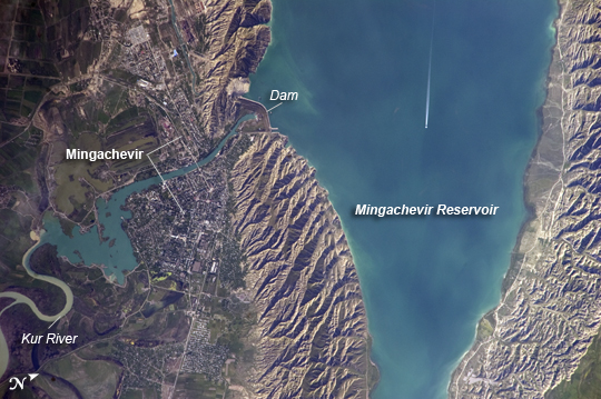 |
| Mingachevir Reservoir, Azerbaijan This detailed astronaut photograph highlights the southern Mingachevir Reservoir in north-central Azerbaijan. The Mingachevir Reservoir occupies part of the Kura Basin, a topographic depression located between the Greater Caucasus Mountains to the northeast and the Lesser Caucasus Mountains to the southwest. Folded layers of relatively young (less than 5. 3 million years old) sedimentary rock, explosive volcanic products (ash and tuff), and unconsolidated sediments form the gray hills along the northern and southern shorelines of the reservoir (image center and right). Afternoon sun highlights distinctive parallel patterns in the hills that are the result of water and wind erosion of different rock layers exposed at the surface. The nearby city of Mingachevir (left) is split by the Kur River after it passes through the dam and hydroelectric power station complex at image top center. The current city was built in support of the hydroelectric power station constructed as part of the then-Soviet Union's energy infrastructure for the region. Today, Mingachevir is the fourth-largest city in Azerbaijan (by population), and it has become a cultural and economic center of the country. The reservoir held approximately 15 billion cubic meters of water at the time this image was taken, with a total engineered capacity of 16 billion cubic meters. The width of the reservoir illustrated here is approximately 8 kilometers (5 miles); a jet flying over the reservoir left a contrail midway between the shorelines. |
| Images: | All Available Images Low-Resolution 232k |
|
| Mission: | ISS023 |
|
| Roll - Frame: | E - 35670 |
|
| Geographical Name: | AZERBAIJAN |
|
| Features: | KURA R., MINGACEVIR RES., DAM, MTS., AGR. |
|
| Center Lat x Lon: | 40.8N x 47.1E |
|
| Film Exposure: | N=Normal exposure, U=Under exposed, O=Over exposed, F=out of Focus |
|
| Percentage of Cloud Cover-CLDP: | 10 |
|
| Camera:: | N5 |
|
| Camera Tilt: | 47 | LO=Low Oblique, HO=High Oblique, NV=Near Vertical |
| Camera Focal Length: | 800 |
|
| Nadir to Photo Center Direction: | W | The direction from the nadir to the center point, N=North, S=South, E=East, W=West |
| Stereo?: | Y=Yes there is an adjacent picture of the same area, N=No there isn't |
|
| Orbit Number: | 1723 |
|
| Date: | 20100508 | YYYYMMDD |
| Time: | 133001 | GMT HHMMSS |
| Nadir Lat: | 41.9N |
Latitude of suborbital point of spacecraft |
| Nadir Lon: | 50.2E |
Longitude of suborbital point of spacecraft |
| Sun Azimuth: | 272 | Clockwise angle in degrees from north to the sun measured at the nadir point |
| Space Craft Altitude: | 187 | nautical miles |
| Sun Elevation: | 23 | Angle in degrees between the horizon and the sun, measured at the nadir point |
| Land Views: | BASIN, EROSION |
|
| Water Views: | RESERVOIR, RIVER |
|
| Atmosphere Views: | |
|
| Man Made Views: | CONTRAIL, DAM |
|
| City Views: | |
|
Photo is not associated with any sequences | ||
| NASA Home Page |
JSC Home Page |
JSC Digital Image Collection |
Earth Science & Remote Sensing |
|
This service is provided by the International Space Station program and the JSC Earth Science & Remote Sensing Unit, ARES Division, Exploration Integration Science Directorate.

|