
Geographic Region: CHILE
Feature: LLULLAILLACO VOL.
|
Geographic Region: CHILE Feature: LLULLAILLACO VOL. |
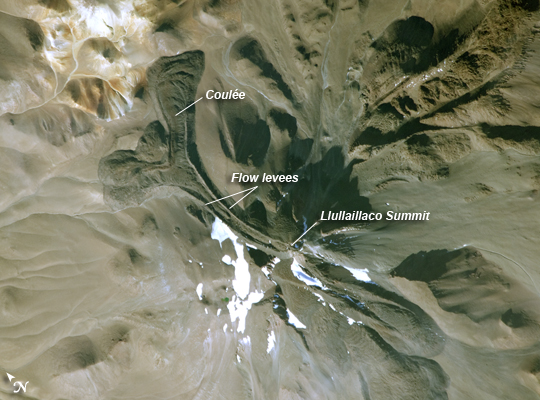 |
| Llullaillaco Volcano, Argentina-Chile Border The summit of South America's Llullaillaco Volcano has an elevation of 6,739 meters (22,110 feet) above sea level, making it the highest historically active volcano in the world. The current stratovolcano--a cone-shaped volcano built from successive layers of thick lava flows and eruption products like ash and rock fragments--is built on top of an older stratovolcano. The last explosive eruption of the volcano, based on historical records, occurred in 1877. This detailed astronaut photograph of Llullaillaco illustrates an interesting volcanic feature known as a coulee (image top right). Coulees are formed from highly viscous, thick lavas that flow onto a steep surface. As they flow slowly downwards, the top of the flow cools and forms a series of parallel ridges oriented at 90 degrees to the direction of flow (somewhat similar in appearance to the pleats of an accordion). The sides of the flow can also cool faster than the center, leading to the formation of wall-like structures known as flow levees (image center). Llullaillaco is also a well-known archaeological site; the mummified remains of three Inca children, ritually sacrificed 500 years ago, were discovered on the summit in 1999. |
| Images: | All Available Images Low-Resolution 225k |
|
| Mission: | ISS022 |
|
| Roll - Frame: | E - 8285 |
|
| Geographical Name: | CHILE |
|
| Features: | LLULLAILLACO VOL. |
|
| Center Lat x Lon: | 24.7S x 68.5W |
|
| Film Exposure: | N=Normal exposure, U=Under exposed, O=Over exposed, F=out of Focus |
|
| Percentage of Cloud Cover-CLDP: | 10 |
|
| Camera:: | N2 |
|
| Camera Tilt: | 23 | LO=Low Oblique, HO=High Oblique, NV=Near Vertical |
| Camera Focal Length: | 800 |
|
| Nadir to Photo Center Direction: | W | The direction from the nadir to the center point, N=North, S=South, E=East, W=West |
| Stereo?: | Y=Yes there is an adjacent picture of the same area, N=No there isn't |
|
| Orbit Number: | 3363 |
|
| Date: | 20091209 | YYYYMMDD |
| Time: | 205702 | GMT HHMMSS |
| Nadir Lat: | 25.2S |
Latitude of suborbital point of spacecraft |
| Nadir Lon: | 67.3W |
Longitude of suborbital point of spacecraft |
| Sun Azimuth: | 256 | Clockwise angle in degrees from north to the sun measured at the nadir point |
| Space Craft Altitude: | 188 | nautical miles |
| Sun Elevation: | 28 | Angle in degrees between the horizon and the sun, measured at the nadir point |
| Land Views: | VOLCANO |
|
| Water Views: | |
|
| Atmosphere Views: | |
|
| Man Made Views: | |
|
| City Views: | |
|
Photo is not associated with any sequences | ||
| NASA Home Page |
JSC Home Page |
JSC Digital Image Collection |
Earth Science & Remote Sensing |
|
This service is provided by the International Space Station program and the JSC Earth Science & Remote Sensing Unit, ARES Division, Exploration Integration Science Directorate.

|