
Geographic Region: USA-TEXAS
Feature: HOUSTON-GALVESTON AREA AT NIGHT
|
Geographic Region: USA-TEXAS Feature: HOUSTON-GALVESTON AREA AT NIGHT |
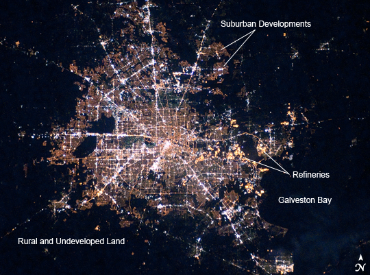 |
| Houston, Texas at Night Houston, Texas has been called the "energy capital of the world" due to its role as a major hub of the petroleum and other energy resource industries. The Houston metropolitan area covers almost 2,331,000 hectares (9,000 square miles) along the southeast Texas coastline, with an average elevation of 13 meters (43 feet) above sea level and a population of over 5 million (2006 US Census estimate). The Houston metropolitan area is also noteworthy as being the largest in the United States without formal zoning restrictions. This has led to a highly diverse pattern of land use at the neighborhood scale; nevertheless, more general spatial patterns of land use can be recognized in remotely sensed data. This is particularly evident in nighttime photography of the urban area taken by astronauts on board the International Space Station. The image depicts the roughly 100 kilometer (60 mile) east-west extent of the Houston metropolitan area. Houston proper is at image center, indicated by a "bull's-eye" of elliptical white to orange-lighted beltways and brightly lit white freeways radiating outwards from the central downtown area. Suburban and primarily residential urban land uses are indicated by both reddish-brown and gray-green lighted regions that reflect a higher proportion of tree cover and lower light density. Petroleum refineries along the Houston Ship Channel are identified by densely lit areas of golden yellow light. Rural and undeveloped land rings the metropolitan area, and Galveston Bay to the southeast (image lower right) provides access to the Gulf of Mexico. Both types of non-urban surface appear dark in the image. You can see more nighttime imagery of cities, and learn about techniques that astronauts use to photograph them in the Earth Observatory feature Cities at Night. |
| Images: | All Available Images Low-Resolution 310k |
|
| Mission: | ISS022 |
|
| Roll - Frame: | E - 78463 |
|
| Geographical Name: | USA-TEXAS |
|
| Features: | HOUSTON-GALVESTON AREA AT NIGHT |
|
| Center Lat x Lon: | 30.0N x 95W |
|
| Film Exposure: | N=Normal exposure, U=Under exposed, O=Over exposed, F=out of Focus |
|
| Percentage of Cloud Cover-CLDP: | 0 |
|
| Camera:: | N3 |
|
| Camera Tilt: | 19 | LO=Low Oblique, HO=High Oblique, NV=Near Vertical |
| Camera Focal Length: | 0 |
|
| Nadir to Photo Center Direction: | NW | The direction from the nadir to the center point, N=North, S=South, E=East, W=West |
| Stereo?: | Y=Yes there is an adjacent picture of the same area, N=No there isn't |
|
| Orbit Number: | 634 |
|
| Date: | 20100228 | YYYYMMDD |
| Time: | 103412 | GMT HHMMSS |
| Nadir Lat: | 29.4N |
Latitude of suborbital point of spacecraft |
| Nadir Lon: | 94.1W |
Longitude of suborbital point of spacecraft |
| Sun Azimuth: | 83 | Clockwise angle in degrees from north to the sun measured at the nadir point |
| Space Craft Altitude: | 189 | nautical miles |
| Sun Elevation: | -29 | Angle in degrees between the horizon and the sun, measured at the nadir point |
| Land Views: | |
|
| Water Views: | BAY, CHANNEL |
|
| Atmosphere Views: | |
|
| Man Made Views: | URBAN AREA |
|
| City Views: | GALVESTON, HOUSTON |
|
Photo is not associated with any sequences | ||
| NASA Home Page |
JSC Home Page |
JSC Digital Image Collection |
Earth Science & Remote Sensing |
|
This service is provided by the International Space Station program and the JSC Earth Science & Remote Sensing Unit, ARES Division, Exploration Integration Science Directorate.

|