Geographic Region: CHILE
Feature: CONCEPCION,HUALPEN,BIO BIO RIVER,AIRPORT
|
Geographic Region: CHILE Feature: CONCEPCION,HUALPEN,BIO BIO RIVER,AIRPORT |
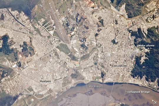 |
| Smoke Plumes over Concepcion, Chile, Following Large Earthquake This detailed astronaut photograph of the Chilean cities of Concepcion and Hualpen was acquired from the International Space Station approximately seven hours after a magnitude 8.8 earthquake occurred offshore 115 kilometers (71 miles) to the north-northeast. Much of the Chilean coastline is located above the boundary between the converging Nazca and South American tectonic plates. This type of plate boundary is known as a subduction zone. Such zones frequently experience moderate to strong earthquakes as one tectonic plate overrides the other. The largest earthquake worldwide during the past 200 years (magnitude 9.5 in May 1960) had a source region approximately 230 kilometers (140 miles) south of the February 27 quake. While the image is not detailed enough to see damage to individual buildings or roadways, some indicators of earthquake damage are visible, especially in the large version of the image. A dark smoke plume is visible at image lower left near an oil refinery in Hualpen. At image lower right, parts of the road bed of a single-lane bridge over the Rio Biobio appear to have collapsed. A smaller, white smoke plume is visible at image right near the Universidad de Concepcion. Smoke, probably related to the earthquake, was observed over Santiago in images acquired by the Moderate Resolution Imaging Spectroradiometer on NASA's Terra satellite less than one hour after this astronaut photograph was taken. |
| Images: | All Available Images Low-Resolution 250k |
|
| Mission: | ISS022 |
|
| Roll - Frame: | E - 74881 |
|
| Geographical Name: | CHILE |
|
| Features: | CONCEPCION,HUALPEN,BIO BIO RIVER,AIRPORT |
|
| Center Lat x Lon: | 36.8S x 73.1W |
|
| Film Exposure: | N=Normal exposure, U=Under exposed, O=Over exposed, F=out of Focus |
|
| Percentage of Cloud Cover-CLDP: | 10 |
|
| Camera:: | N2 |
|
| Camera Tilt: | 29 | LO=Low Oblique, HO=High Oblique, NV=Near Vertical |
| Camera Focal Length: | 800 |
|
| Nadir to Photo Center Direction: | SE | The direction from the nadir to the center point, N=North, S=South, E=East, W=West |
| Stereo?: | Y=Yes there is an adjacent picture of the same area, N=No there isn't |
|
| Orbit Number: | 620 |
|
| Date: | 20100227 | YYYYMMDD |
| Time: | 133538 | GMT HHMMSS |
| Nadir Lat: | 35.3S |
Latitude of suborbital point of spacecraft |
| Nadir Lon: | 74W |
Longitude of suborbital point of spacecraft |
| Sun Azimuth: | 74 | Clockwise angle in degrees from north to the sun measured at the nadir point |
| Space Craft Altitude: | 192 | nautical miles |
| Sun Elevation: | 35 | Angle in degrees between the horizon and the sun, measured at the nadir point |
| Land Views: | |
|
| Water Views: | |
|
| Atmosphere Views: | PLUME, SMOKE |
|
| Man Made Views: | BRIDGE |
|
| City Views: | CONCEPCION, SANTIAGO |
|
Photo is not associated with any sequences | ||
| NASA Home Page |
JSC Home Page |
JSC Digital Image Collection |
Earth Science & Remote Sensing |
|
This service is provided by the International Space Station program and the JSC Earth Science & Remote Sensing Unit, ARES Division, Exploration Integration Science Directorate.

|