
Geographic Region: FRANCE
Feature: GIENS PEN., HYERES, AIRPORT, COAST
|
Geographic Region: FRANCE Feature: GIENS PEN., HYERES, AIRPORT, COAST |
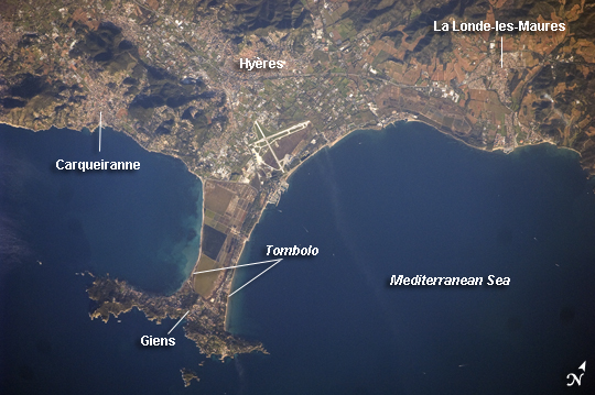 |
| Giens Peninsula, France This detailed astronaut photograph shows the Giens Peninsula, located along the Mediterranean coastline of France. The peninsula is part of the Cote d'Azur, also known as the French Riviera. The coastal region is bounded by the Rhone River to the west, the Rhone Alps to the north, and the Italian border to the east. The peninsula extends southwards from the city of Hyeres to the resort community of Giens. The Giens Peninsula is formed from two tombolos. A tombolo is a ridge of beach material (typically sand), built by wave action, that connects an island to the mainland. Tombolos, like many coastal features, typically change dramatically over geologic time due to fluctuating sediment supply, coastal currents, sea levels and storm events. The tombolos of the Giens Peninsula have been modified by human activities, as well, including sand dune removal, construction of roadways, and replacement of the original sand by other materials. The long-term survival of these tombolos will be determined by the effects of these changes on the natural coastal processes, with potential sea level rise presenting an additional threat. In addition to Giens, three other urban areas are visible in this image: Carqueiranne, Hyeres, and La Londe-les-Maures. The urban areas are recognizable by both light pink rooftops and grey street grids. These colors contrast with green to brown vegetated areas, including agricultural fields between Hyeres and La Londe-les-Maures and more natural vegetation (dark green) on hills between Hyeres and Carqueiranne. Small white dots and streaks in the Mediterranean Sea are yachts and other recreational boats. |
| Images: | All Available Images Low-Resolution 205k |
|
| Mission: | ISS022 |
|
| Roll - Frame: | E - 5403 |
|
| Geographical Name: | FRANCE |
|
| Features: | GIENS PEN., HYERES, AIRPORT, COAST |
|
| Center Lat x Lon: | 43.1N x 6.2E |
|
| Film Exposure: | N=Normal exposure, U=Under exposed, O=Over exposed, F=out of Focus |
|
| Percentage of Cloud Cover-CLDP: | 10 |
|
| Camera:: | N2 |
|
| Camera Tilt: | HO | LO=Low Oblique, HO=High Oblique, NV=Near Vertical |
| Camera Focal Length: | 400 |
|
| Nadir to Photo Center Direction: | NE | The direction from the nadir to the center point, N=North, S=South, E=East, W=West |
| Stereo?: | Y=Yes there is an adjacent picture of the same area, N=No there isn't |
|
| Orbit Number: | 3245 |
|
| Date: | 20091202 | YYYYMMDD |
| Time: | 084556 | GMT HHMMSS |
| Nadir Lat: | 40.5N |
Latitude of suborbital point of spacecraft |
| Nadir Lon: | 2.1E |
Longitude of suborbital point of spacecraft |
| Sun Azimuth: | 138 | Clockwise angle in degrees from north to the sun measured at the nadir point |
| Space Craft Altitude: | 179 | nautical miles |
| Sun Elevation: | 16 | Angle in degrees between the horizon and the sun, measured at the nadir point |
| Land Views: | PENINSULA |
|
| Water Views: | SEA, SEDIMENT |
|
| Atmosphere Views: | |
|
| Man Made Views: | RESORT |
|
| City Views: | |
|
Photo is not associated with any sequences | ||
| NASA Home Page |
JSC Home Page |
JSC Digital Image Collection |
Earth Science & Remote Sensing |
|
This service is provided by the International Space Station program and the JSC Earth Science & Remote Sensing Unit, ARES Division, Exploration Integration Science Directorate.

|