
Geographic Region: UNITED ARAB EMIRATES
Feature: PALM JUMEIRA, THE WORLD I., DUBAI, COAST
|
Geographic Region: UNITED ARAB EMIRATES Feature: PALM JUMEIRA, THE WORLD I., DUBAI, COAST |
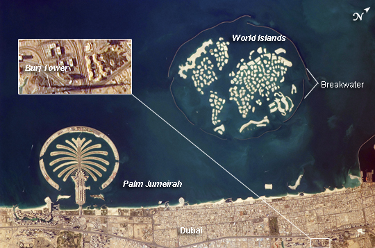 |
| Artificial Archipelagos, Dubai, United Arab Emirates The municipality of Dubai is the largest city of the Persian Gulf emirate of the same name, and has built a global reputation for large-scale developments and architectural works. Among the most visible of these developments--particularly from the perspective of astronauts on board the International Space Station--are three human-made archipelagos. The two Palm Islands (Palm Jumeirah and Palm Jebel Ali) appear as stylized palm trees when viewed from above. The World Islands evoke a rough map of the world from an air- or space-borne perspective. Palm Jumeirah and the World Islands are highlighted in this astronaut photograph. Palm Jumeirah (image lower left) was begun in 2001 and required more than 50 million cubic meters of dredged sand to raise the islands above the Persian Gulf sea level. Construction of the Palm Jumeirah islands was completed in 2006; the islands are now being developed for residential and commercial housing and infrastructure. Creation of the 300 World Islands (image upper right) was begun in 2003 and completed in 2008, using 320 million cubic meters of sand and 37 million tonnes of rock for the surrounding 27-kilometer-long protective breakwater. Little to no infrastructure development of The World is apparent in this astronaut photograph. Also visible at the lower edge of the astronaut photograph is another notable structure--the Burj Khalifa (image lower right and rotated 90 degrees in inset). Burj Khalifa stands 800 meters (2,600 feet) high, and it is currently the world's tallest structure. The astronaut photograph captures enough detail to make out the tapering outline of the building as well as its dark, needle-like shadow pointing towards the northeast. An earlier astronaut photograph shows an early phase of construction of Palm Jumeirah. The Earth Observatory's World of Change feature also tracks urbanization in Dubai. |
| Images: | All Available Images Low-Resolution 244k |
|
| Mission: | ISS022 |
|
| Roll - Frame: | E - 24940 |
|
| Geographical Name: | UNITED ARAB EMIRATES |
|
| Features: | PALM JUMEIRA, THE WORLD I., DUBAI, COAST |
|
| Center Lat x Lon: | 25.2N x 55.1E |
|
| Film Exposure: | N=Normal exposure, U=Under exposed, O=Over exposed, F=out of Focus |
|
| Percentage of Cloud Cover-CLDP: | 10 |
|
| Camera:: | N2 |
|
| Camera Tilt: | 27 | LO=Low Oblique, HO=High Oblique, NV=Near Vertical |
| Camera Focal Length: | 400 |
|
| Nadir to Photo Center Direction: | NE | The direction from the nadir to the center point, N=North, S=South, E=East, W=West |
| Stereo?: | Y=Yes there is an adjacent picture of the same area, N=No there isn't |
|
| Orbit Number: | 3909 |
|
| Date: | 20100113 | YYYYMMDD |
| Time: | 103612 | GMT HHMMSS |
| Nadir Lat: | 23.9N |
Latitude of suborbital point of spacecraft |
| Nadir Lon: | 54.2E |
Longitude of suborbital point of spacecraft |
| Sun Azimuth: | 216 | Clockwise angle in degrees from north to the sun measured at the nadir point |
| Space Craft Altitude: | 183 | nautical miles |
| Sun Elevation: | 36 | Angle in degrees between the horizon and the sun, measured at the nadir point |
| Land Views: | |
|
| Water Views: | GULF |
|
| Atmosphere Views: | |
|
| Man Made Views: | |
|
| City Views: | DUBAI |
|
Photo is not associated with any sequences | ||
| NASA Home Page |
JSC Home Page |
JSC Digital Image Collection |
Earth Science & Remote Sensing |
|
This service is provided by the International Space Station program and the JSC Earth Science & Remote Sensing Unit, ARES Division, Exploration Integration Science Directorate.

|