
Geographic Region: CHILE
Feature: EVAPORATION PONDS, SALAR DE ATACAMA
|
Geographic Region: CHILE Feature: EVAPORATION PONDS, SALAR DE ATACAMA |
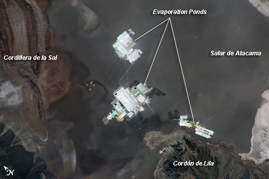 |
| Evaporation Ponds, Salar de Atacama, Chile The Salar de Atacama in Chile is an enclosed basin with no drainage outlets. (Salar is Spanish for "salt flat.") The salar is located in the southern half of the Atacama Desert; with no historical or current records of rainfall in some parts of this desert, it is considered to be one of the driest places on Earth. While the grey-brown surface of the salar is flat and desiccated, mineral-rich brines--water with a high percentage of dissolved salts--are located below the surface. The subsurface brines of the Salar de Atacama are particularly rich in lithium salts. Lithium is an essential component of advanced batteries and medicines. The brines are pumped to the surface through a network of wells and into large, shallow evaporation ponds; three such evaporation facilities are visible in the center of the image. Color variations in the ponds are due to varying amounts of salts relative to water. The dry and windy climate enhances evaporation of the water, leaving concentrated salts behind for extraction of the lithium. This astronaut photograph illustrates the central portion of the Salar de Atacama. It is bounded by brown to grey-brown folded and faulted rock layers of the Cordillera de la Sal to the northwest (image upper left) and darker bedrock of the Cordon de Lila to the south (image lower right). |
| Images: | All Available Images Low-Resolution 151k |
|
| Mission: | ISS022 |
|
| Roll - Frame: | E - 12224 |
|
| Geographical Name: | CHILE |
|
| Features: | EVAPORATION PONDS, SALAR DE ATACAMA |
|
| Center Lat x Lon: | 23.5S x 68.4W |
|
| Film Exposure: | N=Normal exposure, U=Under exposed, O=Over exposed, F=out of Focus |
|
| Percentage of Cloud Cover-CLDP: | 10 |
|
| Camera:: | N2 |
|
| Camera Tilt: | 14 | LO=Low Oblique, HO=High Oblique, NV=Near Vertical |
| Camera Focal Length: | 180 |
|
| Nadir to Photo Center Direction: | SW | The direction from the nadir to the center point, N=North, S=South, E=East, W=West |
| Stereo?: | Y=Yes there is an adjacent picture of the same area, N=No there isn't |
|
| Orbit Number: | 3456 |
|
| Date: | 20091215 | YYYYMMDD |
| Time: | 182521 | GMT HHMMSS |
| Nadir Lat: | 22.8S |
Latitude of suborbital point of spacecraft |
| Nadir Lon: | 68W |
Longitude of suborbital point of spacecraft |
| Sun Azimuth: | 263 | Clockwise angle in degrees from north to the sun measured at the nadir point |
| Space Craft Altitude: | 187 | nautical miles |
| Sun Elevation: | 63 | Angle in degrees between the horizon and the sun, measured at the nadir point |
| Land Views: | BASIN, DESERT, SALAR |
|
| Water Views: | |
|
| Atmosphere Views: | |
|
| Man Made Views: | |
|
| City Views: | |
|
Photo is not associated with any sequences | ||
| NASA Home Page |
JSC Home Page |
JSC Digital Image Collection |
Earth Science & Remote Sensing |
|
This service is provided by the International Space Station program and the JSC Earth Science & Remote Sensing Unit, ARES Division, Exploration Integration Science Directorate.

|