Geographic Region: LESSER ANTILLES
Feature: BARBADOS I., BRIDGETOWN, PORT, BEACHES
|
Geographic Region: LESSER ANTILLES Feature: BARBADOS I., BRIDGETOWN, PORT, BEACHES |
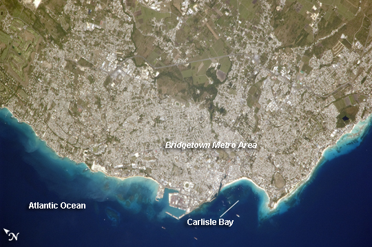 |
| Greater Bridgetown Area, Barbados Bridgetown is the capital city of the island nation Barbados, located to the east of the Lesser Antilles Island chain. While Barbados is considered part of the Lesser Antilles, it is located within the western Atlantic Ocean rather than the Caribbean Sea. Barbados is a member of the British Commonwealth, and considers Queen Elizabeth II to be its constitutional monarch. Besides being the seat of government, Bridgetown is the largest city in Barbados. It and the surrounding towns that make up the Greater Bridgetown area are located along the southwestern coastline of the island. The metropolitan area is readily recognizable in this astronaut photograph due to the gray and white rooftops and street grids (image center) that contrast with green vegetated fields and riverside areas of the island's interior to the northeast (image top center). Bridgetown is a major port destination for both commercial and cruise ships serving the eastern Caribbean--several ships are visible within Carlisle Bay. Water color in the image changes from light blue along the coastline--indicating shallow water--to the dark blue of deeper water away from the island. |
| Images: | Images: | NO IMAGES YET | |||
| Mission: | ISS022 |
||||
| Roll - Frame: | E - 12031 |
||||
| Geographical Name: | LESSER ANTILLES |
||||
| Features: | BARBADOS I., BRIDGETOWN, PORT, BEACHES |
||||
| Center Lat x Lon: | 13.1N x 59.6W |
||||
| Film Exposure: | N=Normal exposure, U=Under exposed, O=Over exposed, F=out of Focus |
||||
| Percentage of Cloud Cover-CLDP: | 10 |
||||
| Camera:: | N2 |
||||
| Camera Tilt: | 27 | LO=Low Oblique, HO=High Oblique, NV=Near Vertical |
|||
| Camera Focal Length: | 800 |
||||
| Nadir to Photo Center Direction: | NW | The direction from the nadir to the center point, N=North, S=South, E=East, W=West |
|||
| Stereo?: | Y=Yes there is an adjacent picture of the same area, N=No there isn't |
||||
| Orbit Number: | 3470 |
||||
| Date: | 20091216 | YYYYMMDD |
|||
| Time: | 153151 | GMT HHMMSS |
|||
| Nadir Lat: | 11.8N |
Latitude of suborbital point of spacecraft | |||
| Nadir Lon: | 58.8W |
Longitude of suborbital point of spacecraft | |||
| Sun Azimuth: | 172 | Clockwise angle in degrees from north to the sun measured at the nadir point |
|||
| Space Craft Altitude: | 182 | nautical miles |
|||
| Sun Elevation: | 55 | Angle in degrees between the horizon and the sun, measured at the nadir point |
|||
| Land Views: | ISLAND |
||||
| Water Views: | BAY, OCEAN |
||||
| Atmosphere Views: | |
||||
| Man Made Views: | PORT |
||||
| City Views: | BRIDGETOWN |
||||
Photo is not associated with any sequences | |||||
| NASA Home Page |
JSC Home Page |
JSC Digital Image Collection |
Earth Science & Remote Sensing |
|
This service is provided by the International Space Station program and the JSC Earth Science & Remote Sensing Unit, ARES Division, Exploration Integration Science Directorate.

|