Geographic Region: CHAD
Feature: OUNIANGA SERIR LAKE
|
Geographic Region: CHAD Feature: OUNIANGA SERIR LAKE |
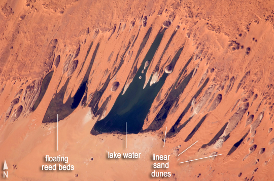 |
| Ounianga Lakes, Sahara Desert, Chad This astronaut photograph features one of the largest of a series of ten mostly fresh water lakes in the Ounianga Basin in the heart of the Sahara Desert of northeastern Chad. The lakes are remnants of a single large lake, probably tens of kilometers long, that once occupied this remote area approximately 14,800 to 5,500 years ago. As the climate dried out during the subsequent millennia, the lake shrank, and large, wind-driven sand dunes invaded the original depression, dividing it into several smaller basins. The area shown in this image is approximately 11 by 9 kilometers. The lakes' dark surfaces are almost completely segregated by linear, orange sand dunes that stream into the depression from the northeast. The almost-year-round northeast winds and cloudless skies make for very high evaporation rates; an evaporation rate of more than 6 meters per year has been measured in one of the nearby lakes. Despite this, only one of the ten lakes is saline. The reason for the apparent paradox--fresh water lakes in the heart of the desert--is that fresh water from a very large aquifer reaches the surface in the Ounianga Depression. The aquifer is large enough to keep supplying the small lakes with water despite the high evaporation rate. Mats of floating reeds also reduce the evaporation in places. The lakes form a hydrological system that is unique in the Sahara Desert. The aquifer was charged with fresh water and the original lake evolved during the African Humid Period (about 14,800 to 5,500 years ago), when the West African summer monsoon was stronger than it is today. Associated southerly winds brought Atlantic moisture well north of modern limits, producing sufficient rainfall in the central Sahara to foster an almost complete savanna vegetation cover. Pollen data from lake sediments of the original 50-meter-deep Ounianga Lake suggest to scientists that a mild tropical climate and a wooded grassland/savanna ecosystem existed in the region. Ferns grew in the stream floodplains. The same vegetation groups are now only encountered 300 kilometers farther south. Even shrubs that now occur only on the very high, cool summits (above 2,900 meters) of the Tibesti Mountains have been found in the Ounianga Lake sediments. |
| Images: | All Available Images Low-Resolution 263k |
|
| Mission: | ISS021 |
|
| Roll - Frame: | E - 26475 |
|
| Geographical Name: | CHAD |
|
| Features: | OUNIANGA SERIR LAKE |
|
| Center Lat x Lon: | 18.9N x 20.9E |
|
| Film Exposure: | N=Normal exposure, U=Under exposed, O=Over exposed, F=out of Focus |
|
| Percentage of Cloud Cover-CLDP: | 0 |
|
| Camera:: | N2 |
|
| Camera Tilt: | 28 | LO=Low Oblique, HO=High Oblique, NV=Near Vertical |
| Camera Focal Length: | 800 |
|
| Nadir to Photo Center Direction: | S | The direction from the nadir to the center point, N=North, S=South, E=East, W=West |
| Stereo?: | Y=Yes there is an adjacent picture of the same area, N=No there isn't |
|
| Orbit Number: | 2964 |
|
| Date: | 20091114 | YYYYMMDD |
| Time: | 130457 | GMT HHMMSS |
| Nadir Lat: | 20.4N |
Latitude of suborbital point of spacecraft |
| Nadir Lon: | 21.4E |
Longitude of suborbital point of spacecraft |
| Sun Azimuth: | 229 | Clockwise angle in degrees from north to the sun measured at the nadir point |
| Space Craft Altitude: | 181 | nautical miles |
| Sun Elevation: | 34 | Angle in degrees between the horizon and the sun, measured at the nadir point |
| Land Views: | BASIN, DESERT |
|
| Water Views: | LAKE |
|
| Atmosphere Views: | |
|
| Man Made Views: | |
|
| City Views: | |
|
Photo is not associated with any sequences | ||
| NASA Home Page |
JSC Home Page |
JSC Digital Image Collection |
Earth Science & Remote Sensing |
|
This service is provided by the International Space Station program and the JSC Earth Science & Remote Sensing Unit, ARES Division, Exploration Integration Science Directorate.

|