
Geographic Region: EL SALVADOR
Feature: LLOPANGO, LAKE, R. JIBOA, FOREST, MTS., AGR.
|
Geographic Region: EL SALVADOR Feature: LLOPANGO, LAKE, R. JIBOA, FOREST, MTS., AGR. |
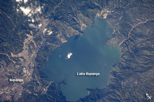 |
| Lake Ilopango, El Salvador The Central American country of El Salvador occupies a land area nearly the same size as the U.S. State of Massachusetts, and it includes numerous historically active volcanoes. This detailed astronaut photograph highlights the Ilopango Caldera that is located approximately 16 kilometers to the east of the capital city, San Salvador. Calderas are the geologic record of powerful volcanic eruptions that empty out a volcano's magma chamber; following the eruption, the overlying volcanic structure collapses into the newly formed void, leaving a large crater-like feature (the caldera). The last caldera-forming eruption at Ilopango occurred during the fifth century AD; it was a powerful event that produced pyroclastic flows that destroyed early Mayan cities in the region. Later volcanic activity included the formation of several lava domes within the lake-filled caldera and near the shoreline. The only historical eruption at Ilopango took place in 1879-80. This activity resulted in the formation of a lava dome in the center of Lake Ilopango. The summit of the dome forms small islets known as Islas Quemadas (visible as small white dots in the larger image). The city of Ilopango borders the lake to the west (image left), while green, vegetated hills ring the rest of the shoreline. White, patchy cumulus clouds are also visible in the image (center and upper left). |
| Images: | All Available Images Low-Resolution 268k |
|
| Mission: | ISS021 |
|
| Roll - Frame: | E - 23475 |
|
| Geographical Name: | EL SALVADOR |
|
| Features: | LLOPANGO, LAKE, R. JIBOA, FOREST, MTS., AGR. |
|
| Center Lat x Lon: | 13.7N x 89W |
|
| Film Exposure: | N=Normal exposure, U=Under exposed, O=Over exposed, F=out of Focus |
|
| Percentage of Cloud Cover-CLDP: | 10 |
|
| Camera:: | N2 |
|
| Camera Tilt: | 11 | LO=Low Oblique, HO=High Oblique, NV=Near Vertical |
| Camera Focal Length: | 400 |
|
| Nadir to Photo Center Direction: | SW | The direction from the nadir to the center point, N=North, S=South, E=East, W=West |
| Stereo?: | Y=Yes there is an adjacent picture of the same area, N=No there isn't |
|
| Orbit Number: | 2922 |
|
| Date: | 20091111 | YYYYMMDD |
| Time: | 210834 | GMT HHMMSS |
| Nadir Lat: | 14.2N |
Latitude of suborbital point of spacecraft |
| Nadir Lon: | 88.7W |
Longitude of suborbital point of spacecraft |
| Sun Azimuth: | 240 | Clockwise angle in degrees from north to the sun measured at the nadir point |
| Space Craft Altitude: | 182 | nautical miles |
| Sun Elevation: | 29 | Angle in degrees between the horizon and the sun, measured at the nadir point |
| Land Views: | CALDERA, CRATER, VOLCANO |
|
| Water Views: | LAKE |
|
| Atmosphere Views: | |
|
| Man Made Views: | |
|
| City Views: | |
|
Photo is not associated with any sequences | ||
| NASA Home Page |
JSC Home Page |
JSC Digital Image Collection |
Earth Science & Remote Sensing |
|
This service is provided by the International Space Station program and the JSC Earth Science & Remote Sensing Unit, ARES Division, Exploration Integration Science Directorate.

|