Geographic Region: USA-HAWAII
Feature: PEARL HARBOR, PEARL CITY, WAIPAHU
|
Geographic Region: USA-HAWAII Feature: PEARL HARBOR, PEARL CITY, WAIPAHU |
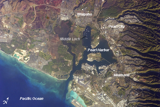 |
| Pearl Harbor, Hawaii This detailed astronaut photograph illustrates the southern coastline of the Hawaiian island Oahu, including Pearl Harbor. On December 7, 1941--68 years ago--a surprise attack by the Japanese Navy on Pearl Harbor and other targets on the island of Oahu precipitated the entry of the United States into World War II. Today, Pearl Harbor is still in use as a major United States Navy installation, and along with Honolulu, it is one of the most heavily developed parts of the island. A comparison between this image and a 2003 astronaut photograph of Pearl Harbor suggests that little observable land use or land cover change has occurred in the area over the past six years. The most significant difference is the presence of more naval vessels in the Reserve Fleet anchorage in Middle Loch (image center). The urban areas of Waipahu, Pearl City, and Aliamanu border the harbor to the northwest, north, and east. The built-up areas, recognizable by linear streets and white rooftops, contrast sharply with the reddish volcanic soils and green vegetation on the surrounding hills. |
| Images: | All Available Images Low-Resolution 273k |
|
| Mission: | ISS021 |
|
| Roll - Frame: | E - 15710 |
|
| Geographical Name: | USA-HAWAII |
|
| Features: | PEARL HARBOR, PEARL CITY, WAIPAHU |
|
| Center Lat x Lon: | 21.4N x 158W |
|
| Film Exposure: | N=Normal exposure, U=Under exposed, O=Over exposed, F=out of Focus |
|
| Percentage of Cloud Cover-CLDP: | 10 |
|
| Camera:: | N2 |
|
| Camera Tilt: | 8 | LO=Low Oblique, HO=High Oblique, NV=Near Vertical |
| Camera Focal Length: | 400 |
|
| Nadir to Photo Center Direction: | W | The direction from the nadir to the center point, N=North, S=South, E=East, W=West |
| Stereo?: | Y=Yes there is an adjacent picture of the same area, N=No there isn't |
|
| Orbit Number: | 2683 |
|
| Date: | 20091027 | YYYYMMDD |
| Time: | 175732 | GMT HHMMSS |
| Nadir Lat: | 21.5N |
Latitude of suborbital point of spacecraft |
| Nadir Lon: | 157.6W |
Longitude of suborbital point of spacecraft |
| Sun Azimuth: | 113 | Clockwise angle in degrees from north to the sun measured at the nadir point |
| Space Craft Altitude: | 185 | nautical miles |
| Sun Elevation: | 18 | Angle in degrees between the horizon and the sun, measured at the nadir point |
| Land Views: | ISLAND |
|
| Water Views: | |
|
| Atmosphere Views: | |
|
| Man Made Views: | HARBOR |
|
| City Views: | ANCHORAGE |
|
Photo is not associated with any sequences | ||
| NASA Home Page |
JSC Home Page |
JSC Digital Image Collection |
Earth Science & Remote Sensing |
|
This service is provided by the International Space Station program and the JSC Earth Science & Remote Sensing Unit, ARES Division, Exploration Integration Science Directorate.

|