Geographic Region: ARGENTINA
Feature: UPSALA GLACIER,ICEBERGS,LAKE ARGENTINO,MORAINES
|
Geographic Region: ARGENTINA Feature: UPSALA GLACIER,ICEBERGS,LAKE ARGENTINO,MORAINES |
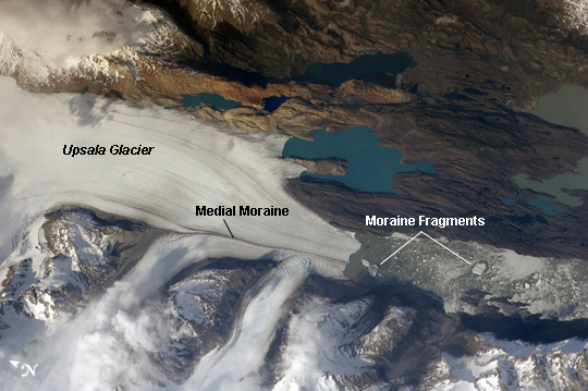 |
| Upsala Glacier, Argentina The Southern Patagonian Icefield of Argentina and Chile is the southern remnant of the Patagonia Ice Sheet that covered the southern Andes Mountains during the last ice age. This detailed astronaut photograph illustrates the terminus of one of the icefield's many spectacular glaciers--Upsala Glacier, located on the eastern side of the icefield. Upsala is the third largest glacier in the icefield, and like most other glaciers in the region, it has experienced significant retreat over the past century. This image was taken during spring in the Southern Hemisphere, and icebergs were calving from the glacier terminus into the waters of Lago Argentino (Lake Argentina, image right). Two icebergs are especially interesting because they retain fragments of the moraine (rock debris) that forms a dark line along the upper surface of the glacier. The inclusion of the moraine illustrates how land-based rocks and sediment may wind up in ocean sediments far from shore. Moraines are formed from rock and soil debris that accumulate along the front and sides of a flowing glacier. The glacier is like a bulldozer that pushes soil and rock in front of it, leaving debris on either side. When two glaciers merge (image center), moraines along their edges can join to form a medial moraine that is drawn out along the upper surface of the new glacier. The moraine can be carried intact to the terminus and included in icebergs that then float away, dropping the coarse debris as the iceberg melts. While the icebergs produced by Upsala Glacier do not reach an ocean, many current glaciers do. The existence of ancient glaciers and ice sheets is recorded by layers or pockets of coarse, land-derived sediments within finer-grained sea floor sediments that are located far from any current (or former) coastline. |
| Images: | Images: | NO IMAGES YET | |||
| Mission: | ISS021 |
||||
| Roll - Frame: | E - 15243 |
||||
| Geographical Name: | ARGENTINA |
||||
| Features: | UPSALA GLACIER,ICEBERGS,LAKE ARGENTINO,MORAINES |
||||
| Center Lat x Lon: | 49.9S x 73.3W |
||||
| Film Exposure: | N=Normal exposure, U=Under exposed, O=Over exposed, F=out of Focus |
||||
| Percentage of Cloud Cover-CLDP: | 10 |
||||
| Camera:: | N2 |
||||
| Camera Tilt: | HO | LO=Low Oblique, HO=High Oblique, NV=Near Vertical |
|||
| Camera Focal Length: | 400 |
||||
| Nadir to Photo Center Direction: | W | The direction from the nadir to the center point, N=North, S=South, E=East, W=West |
|||
| Stereo?: | Y=Yes there is an adjacent picture of the same area, N=No there isn't |
||||
| Orbit Number: | 2653 |
||||
| Date: | 20091025 | YYYYMMDD |
|||
| Time: | 205007 | GMT HHMMSS |
|||
| Nadir Lat: | 50.5S |
Latitude of suborbital point of spacecraft | |||
| Nadir Lon: | 63.5W |
Longitude of suborbital point of spacecraft | |||
| Sun Azimuth: | 275 | Clockwise angle in degrees from north to the sun measured at the nadir point |
|||
| Space Craft Altitude: | 186 | nautical miles |
|||
| Sun Elevation: | 20 | Angle in degrees between the horizon and the sun, measured at the nadir point |
|||
| Land Views: | GLACIER |
||||
| Water Views: | ICE, LAKE |
||||
| Atmosphere Views: | |
||||
| Man Made Views: | |
||||
| City Views: | |
||||
Photo is not associated with any sequences | |||||
| NASA Home Page |
JSC Home Page |
JSC Digital Image Collection |
Earth Science & Remote Sensing |
|
This service is provided by the International Space Station program and the JSC Earth Science & Remote Sensing Unit, ARES Division, Exploration Integration Science Directorate.

|