Geographic Region: ATLANTIC OCEAN I(S).
Feature: SAVAGE ISLANDS, SELVAGEM GRANDE
|
Geographic Region: ATLANTIC OCEAN I(S). Feature: SAVAGE ISLANDS, SELVAGEM GRANDE |
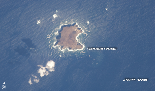 |
| Savage Islands, Atlantic Ocean The Savage Islands, or Ilhas Selvagens in Portuguese, are a small archipelago in the eastern North Atlantic Ocean between the archipelago of Madeira to the north and the Canary Islands to the south. Like these other island groups, the Savage Islands are thought to have been produced by volcanism related to a mantle plume or "hot spot." Typically, volcanoes are fueled by magma being generated where tectonic plates are colliding or being pulled apart. The active volcanoes remain at the plate boundaries, even as the plates shift. Mantle plumes, in contrast, are relatively fixed regions of upwelling magma that can feed volcanoes on an overlying tectonic plate. When a tectonic plate passes over the mantle plume, active volcanoes form, but they become dormant as they are carried away from the hot spot on the moving tectonic plate. Over geologic time, this creates a line of older, extinct volcanoes, seamounts, and islands extending from the active volcanoes that are currently over the plume. These two astronaut photographs illustrate the northern (top) and southern (bottom) Savage Islands. The two views were taken 13 seconds apart from the International Space Station; the geographic center points of the images are separated by about 15 kilometers. Selvagem Grande, with an approximate area of 4 square kilometers, is the largest of the islands. The smaller and more irregularly-shaped Ilheus do Norte, Ilheu de Fora, and Selvagem Pequena are visible at the center of the lower image. Spain and Portugal both claim sovereignty over the Savage Islands. All of the islands of the archipelago are ringed by bright white breaking waves along the fringing beaches. Reefs that surround the Savage Islands make it very difficult to land boats there, and there is no permanent settlement on the islands. The islands serve as nesting sites for several species of seabird including petrels and shearwaters, and they are included on the tentative list of additional UNESCO World Heritage Sites. |
| Images: | All Available Images Low-Resolution 157k |
|
| Mission: | ISS021 |
|
| Roll - Frame: | E - 11832 |
|
| Geographical Name: | ATLANTIC OCEAN I(S). |
|
| Features: | SAVAGE ISLANDS, SELVAGEM GRANDE |
|
| Center Lat x Lon: | 30.2N x 15.9W |
|
| Film Exposure: | N=Normal exposure, U=Under exposed, O=Over exposed, F=out of Focus |
|
| Percentage of Cloud Cover-CLDP: | 10 |
|
| Camera:: | N2 |
|
| Camera Tilt: | 32 | LO=Low Oblique, HO=High Oblique, NV=Near Vertical |
| Camera Focal Length: | 800 |
|
| Nadir to Photo Center Direction: | SE | The direction from the nadir to the center point, N=North, S=South, E=East, W=West |
| Stereo?: | Y=Yes there is an adjacent picture of the same area, N=No there isn't |
|
| Orbit Number: | 2599 |
|
| Date: | 20091022 | YYYYMMDD |
| Time: | 100054 | GMT HHMMSS |
| Nadir Lat: | 31.8N |
Latitude of suborbital point of spacecraft |
| Nadir Lon: | 16.9W |
Longitude of suborbital point of spacecraft |
| Sun Azimuth: | 129 | Clockwise angle in degrees from north to the sun measured at the nadir point |
| Space Craft Altitude: | 184 | nautical miles |
| Sun Elevation: | 31 | Angle in degrees between the horizon and the sun, measured at the nadir point |
| Land Views: | ISLAND |
|
| Water Views: | OCEAN |
|
| Atmosphere Views: | |
|
| Man Made Views: | |
|
| City Views: | |
|
Photo is not associated with any sequences | ||
| NASA Home Page |
JSC Home Page |
JSC Digital Image Collection |
Earth Science & Remote Sensing |
|
This service is provided by the International Space Station program and the JSC Earth Science & Remote Sensing Unit, ARES Division, Exploration Integration Science Directorate.

|