Geographic Region: INDONESIA
Feature: MOUNT TAMBORA, SUMBAWA ISLAND, CALDERA
|
Geographic Region: INDONESIA Feature: MOUNT TAMBORA, SUMBAWA ISLAND, CALDERA |
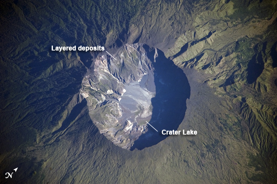 |
| Mount Tambora Volcano, Sumbawa Island, Indonesia On April 10, 1815, the Tambora Volcano produced the largest eruption in history. An estimated 150 cubic kilometers of tephra--exploded rock and ash--resulted, with ash from the eruption recognized at least 1,300 kilometers away to the northwest. While the April 10 eruption was catastrophic, historical records and geological analysis of eruption deposits indicate that the volcano had been active between 1812 and 1815. Enough ash was put into the atmosphere from the April 10 eruption to reduce incident sunlight on the Earth's surface and cause global cooling, resulting in the 1816 "year without a summer." This detailed astronaut photograph depicts the summit caldera of the volcano. The huge caldera--6 kilometers in diameter and 1,100 meters deep--formed when Tambora's estimated 4,000-meter-high peak was removed, and the magma chamber below emptied during the April 10 eruption. Today the crater floor is occupied by an ephemeral freshwater lake, recent sedimentary deposits, and minor lava flows and domes emplaced during the nineteenth and twentieth centuries. Layered tephra deposits are visible along the northwestern crater rim. Active fumaroles, or steam vents, still exist in the caldera. In 2004, scientists discovered the remains of a village, and two adults buried under approximately 3 meters of ash in a gully on Tambora's flank--remnants of the former Kingdom of Tambora preserved by the 1815 eruption that destroyed it. The similarity of the Tambora remains to those associated with the AD 79 eruption of Mount Vesuvius has led to the Tambora site's description as "the Pompeii of the East." |
| Images: | All Available Images Low-Resolution 219k |
|
| Mission: | ISS020 |
|
| Roll - Frame: | E - 6563 |
|
| Geographical Name: | INDONESIA |
|
| Features: | MOUNT TAMBORA, SUMBAWA ISLAND, CALDERA |
|
| Center Lat x Lon: | 8.3S x 118.0E |
|
| Film Exposure: | N=Normal exposure, U=Under exposed, O=Over exposed, F=out of Focus |
|
| Percentage of Cloud Cover-CLDP: | 10 |
|
| Camera:: | N3 |
|
| Camera Tilt: | 27 | LO=Low Oblique, HO=High Oblique, NV=Near Vertical |
| Camera Focal Length: | 800 |
|
| Nadir to Photo Center Direction: | W | The direction from the nadir to the center point, N=North, S=South, E=East, W=West |
| Stereo?: | Y=Yes there is an adjacent picture of the same area, N=No there isn't |
|
| Orbit Number: | 371 |
|
| Date: | 20090603 | YYYYMMDD |
| Time: | 000806 | GMT HHMMSS |
| Nadir Lat: | 8.2S |
Latitude of suborbital point of spacecraft |
| Nadir Lon: | 119.6E |
Longitude of suborbital point of spacecraft |
| Sun Azimuth: | 60 | Clockwise angle in degrees from north to the sun measured at the nadir point |
| Space Craft Altitude: | 189 | nautical miles |
| Sun Elevation: | 26 | Angle in degrees between the horizon and the sun, measured at the nadir point |
| Land Views: | CALDERA, CRATER, VOLCANO |
|
| Water Views: | LAKE |
|
| Atmosphere Views: | |
|
| Man Made Views: | |
|
| City Views: | |
|
Photo is not associated with any sequences | ||
| NASA Home Page |
JSC Home Page |
JSC Digital Image Collection |
Earth Science & Remote Sensing |
|
This service is provided by the International Space Station program and the JSC Earth Science & Remote Sensing Unit, ARES Division, Exploration Integration Science Directorate.

|