Geographic Region: BRAZIL
Feature: SUNGLINT, RIO MADEIRA, LAGO ACARA, LINE OF CUMULONIMBUS CLOUDS
|
Geographic Region: BRAZIL Feature: SUNGLINT, RIO MADEIRA, LAGO ACARA, LINE OF CUMULONIMBUS CLOUDS |
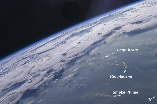 |
| Thunderstorms on the Brazilian Horizon A picturesque line of thunderstorms and numerous circular cloud patterns filled the view as the International Space Station (ISS) Expedition 20 crew members looked out at the limb (blue line on the horizon) of the Earth. The region shown in the astronaut photograph (top image) includes an unstable, active atmosphere forming a large area of cumulonimbus clouds in various stages of development. The crew was looking west-southwest from the Amazon Basin, along the Rio Madeira toward Bolivia when the image was taken. The semi-circular cloud patterns near the center of the astronaut photograph may be detected in a Geostationary Operational Environmental Satellite (GOES) infrared satellite image of the region (bottom image, yellow rectangle) acquired about 20 minutes earlier than the astronaut photograph. The distinctive circular patterns of the clouds in the astronaut photograph are likely caused by the aging of thunderstorms. Such ring structures often form during the final stages of storms' development as their centers collapse. Sunglint--the mirror-like reflection of sunlight off a water surface directly back to the camera onboard the ISS--is visible on the waters of the Rio Madeira and Lago Acara in the Amazon Basin. Widespread haze over the basin gives the reflected light an orange hue. The Rio Madeira flows northward and joins the Amazon River on its path to the Atlantic Ocean. A large smoke plume near the bottom center of the image may be one source of the haze. |
| Images: | All Available Images Low-Resolution 159k |
|
| Mission: | ISS020 |
|
| Roll - Frame: | E - 47807 |
|
| Geographical Name: | BRAZIL |
|
| Features: | SUNGLINT, RIO MADEIRA, LAGO ACARA, LINE OF CUMULONIMBUS CLOUDS |
|
| Center Lat x Lon: | 7S x 62.5W |
|
| Film Exposure: | N=Normal exposure, U=Under exposed, O=Over exposed, F=out of Focus |
|
| Percentage of Cloud Cover-CLDP: | 100 |
|
| Camera:: | N2 |
|
| Camera Tilt: | HO | LO=Low Oblique, HO=High Oblique, NV=Near Vertical |
| Camera Focal Length: | 48 |
|
| Nadir to Photo Center Direction: | W | The direction from the nadir to the center point, N=North, S=South, E=East, W=West |
| Stereo?: | Y=Yes there is an adjacent picture of the same area, N=No there isn't |
|
| Orbit Number: | 2354 |
|
| Date: | 20091006 | YYYYMMDD |
| Time: | 210653 | GMT HHMMSS |
| Nadir Lat: | 5.4S |
Latitude of suborbital point of spacecraft |
| Nadir Lon: | 54.8W |
Longitude of suborbital point of spacecraft |
| Sun Azimuth: | 265 | Clockwise angle in degrees from north to the sun measured at the nadir point |
| Space Craft Altitude: | 184 | nautical miles |
| Sun Elevation: | 6 | Angle in degrees between the horizon and the sun, measured at the nadir point |
| Land Views: | BASIN |
|
| Water Views: | OCEAN, RIVER, SUNGLINT |
|
| Atmosphere Views: | HAZE, PLUME, SMOKE |
|
| Man Made Views: | |
|
| City Views: | |
|
Photo is not associated with any sequences | ||
| NASA Home Page |
JSC Home Page |
JSC Digital Image Collection |
Earth Science & Remote Sensing |
|
This service is provided by the International Space Station program and the JSC Earth Science & Remote Sensing Unit, ARES Division, Exploration Integration Science Directorate.

|