
Geographic Region: UNITED ARAB EMIRATES
Feature: CITY OF DUBAI AT NIGHT, PALM ISLAND RESORT,PERSIAN GULF
|
Geographic Region: UNITED ARAB EMIRATES Feature: CITY OF DUBAI AT NIGHT, PALM ISLAND RESORT,PERSIAN GULF |
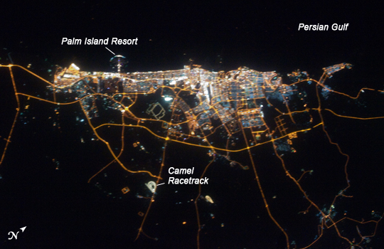 |
| City of Dubai at night, United Arab Emirates The city of Dubai is the largest metropolitan area in the emirate of Dubai, one of the member states of the United Arab Emirates. Dubai is located along the southern Persian Gulf on the Arabian Peninsula, and its signature city is known for high profile architectural and development projects. Among the most notable is the Palm Jumeirah, a man-made peninsula and surrounding islands built from over 50 million cubic meters of sand. Three other island projects, two similar to Palm Jumeirah and another crafted to look like a map of the world, are also underway along the Dubai coastline. This nighttime astronaut photograph of the city of Dubai was taken at approximately 2 a.m. local time on September 11, 2009. Orange sodium vapor lights trace the major highways and street grid in and around the metropolitan area, while grey-white mercury vapor lamps fill in the commercial and residential areas. The lighted islands and peninsula of Palm Jumeirah are clearly visible along the coastline. A spiral pattern of lights on the southeastern fringe of the urban area is a camel racetrack. Nighttime images like these are useful to climate modelers, urban planners, and geographers as they allow for simple definition of urban (densely lit) and rural (sparely lit) areas. |
| Images: | All Available Images Low-Resolution 191k |
|
| Mission: | ISS020 |
|
| Roll - Frame: | E - 39932 |
|
| Geographical Name: | UNITED ARAB EMIRATES |
|
| Features: | CITY OF DUBAI AT NIGHT, PALM ISLAND RESORT,PERSIAN GULF |
|
| Center Lat x Lon: | 25.1N x 55.1E |
|
| Film Exposure: | N=Normal exposure, U=Under exposed, O=Over exposed, F=out of Focus |
|
| Percentage of Cloud Cover-CLDP: | 0 |
|
| Camera:: | N3 |
|
| Camera Tilt: | 3 | LO=Low Oblique, HO=High Oblique, NV=Near Vertical |
| Camera Focal Length: | 80 |
|
| Nadir to Photo Center Direction: | SW | The direction from the nadir to the center point, N=North, S=South, E=East, W=West |
| Stereo?: | Y=Yes there is an adjacent picture of the same area, N=No there isn't |
|
| Orbit Number: | 1961 |
|
| Date: | 20090911 | YYYYMMDD |
| Time: | 221427 | GMT HHMMSS |
| Nadir Lat: | 25.2N |
Latitude of suborbital point of spacecraft |
| Nadir Lon: | 55.2E |
Longitude of suborbital point of spacecraft |
| Sun Azimuth: | 49 | Clockwise angle in degrees from north to the sun measured at the nadir point |
| Space Craft Altitude: | 185 | nautical miles |
| Sun Elevation: | -49 | Angle in degrees between the horizon and the sun, measured at the nadir point |
| Land Views: | ISLAND, PENINSULA |
|
| Water Views: | GULF |
|
| Atmosphere Views: | |
|
| Man Made Views: | URBAN AREA |
|
| City Views: | DUBAI |
|
Photo is not associated with any sequences | ||
| NASA Home Page |
JSC Home Page |
JSC Digital Image Collection |
Earth Science & Remote Sensing |
|
This service is provided by the International Space Station program and the JSC Earth Science & Remote Sensing Unit, ARES Division, Exploration Integration Science Directorate.

|