Geographic Region: CHILE
Feature: ICE FLOES,FJORDS,PENGUIN GLACIER
|
Geographic Region: CHILE Feature: ICE FLOES,FJORDS,PENGUIN GLACIER |
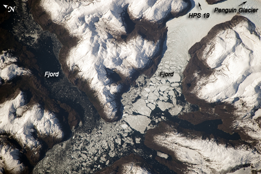 |
| Glacier Outlet, Southern Patagonian Ice Field, Chile The Southern Patagonian Ice Field of Chile and Argentina hosts a spectacular array of glaciers and associated glacial features within the southern Andes Mountains. Glaciers flowing downhill on the eastern side of the mountains have outlets into several large freshwater lakes. On the western side of the mountains, glaciers release ice into the Pacific Ocean via an intricate network of fjords. Fjords are steep valleys originally cut by glaciers during periods of lower sea level that are now inundated. As glaciers flow into the fjord, ice at the front of the glacier begins to break off and form icebergs that can float out to sea--a process known as calving. This detailed astronaut photograph shows the merged outlet of Penguin Glacier and HPS 19 into a fjord carved into the snow-covered mountains of the southern Andes. The designation HPS stands for Hielo Patagonico Sur (Southern Patagonian Icefield) and is used to identify glaciers that have no other geographic name. Ice flowing into the fjord begins to break up at image center, forming numerous icebergs. The largest visible in this image is approximately 2 kilometers in width. The large ice masses visible at image center have a coarse granular appearance due to variable snow cover, and mixing and refreezing of ice fragments prior to floating free. |
| Images: | All Available Images Low-Resolution 260k |
|
| Mission: | ISS020 |
|
| Roll - Frame: | E - 39083 |
|
| Geographical Name: | CHILE |
|
| Features: | ICE FLOES,FJORDS,PENGUIN GLACIER |
|
| Center Lat x Lon: | 50S x 74W |
|
| Film Exposure: | N=Normal exposure, U=Under exposed, O=Over exposed, F=out of Focus |
|
| Percentage of Cloud Cover-CLDP: | 10 |
|
| Camera:: | N3 |
|
| Camera Tilt: | 11 | LO=Low Oblique, HO=High Oblique, NV=Near Vertical |
| Camera Focal Length: | 800 |
|
| Nadir to Photo Center Direction: | SW | The direction from the nadir to the center point, N=North, S=South, E=East, W=West |
| Stereo?: | Y=Yes there is an adjacent picture of the same area, N=No there isn't |
|
| Orbit Number: | 1879 |
|
| Date: | 20090906 | YYYYMMDD |
| Time: | 175235 | GMT HHMMSS |
| Nadir Lat: | 49.6S |
Latitude of suborbital point of spacecraft |
| Nadir Lon: | 73.5W |
Longitude of suborbital point of spacecraft |
| Sun Azimuth: | 342 | Clockwise angle in degrees from north to the sun measured at the nadir point |
| Space Craft Altitude: | 192 | nautical miles |
| Sun Elevation: | 33 | Angle in degrees between the horizon and the sun, measured at the nadir point |
| Land Views: | GLACIER |
|
| Water Views: | FRONT, ICE, OCEAN, SEA |
|
| Atmosphere Views: | |
|
| Man Made Views: | |
|
| City Views: | |
|
Photo is not associated with any sequences | ||
| NASA Home Page |
JSC Home Page |
JSC Digital Image Collection |
Earth Science & Remote Sensing |
|
This service is provided by the International Space Station program and the JSC Earth Science & Remote Sensing Unit, ARES Division, Exploration Integration Science Directorate.

|