
Geographic Region: USA-ARIZONA
Feature: BLACK POINT LAVA FLOW, LITTLE COLORADO RIVER, RAVINES, ROAD
|
Geographic Region: USA-ARIZONA Feature: BLACK POINT LAVA FLOW, LITTLE COLORADO RIVER, RAVINES, ROAD |
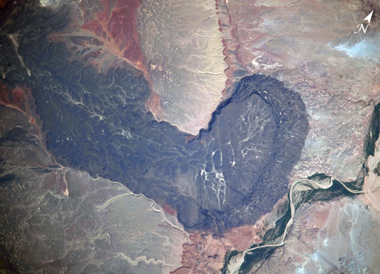 |
| Black Point Lava Flow, Arizona The otherworldly footprint of black basaltic lava creates a striking landscape at Black Point Lava Flow in northern Arizona, seen in this photograph taken from the International Space Station. The flow is part of Arizona's San Francisco Volcanic Field, a group of geologically young (approximately six million to less than one thousand years old) volcanoes, lava flows, and cinder cones located just north of Flagstaff, Arizona. When it erupted onto the surface, the Black Point Lava flowed eastward over the older Permian and Triassic sedimentary rock sequences (spanning the period from roughly 300 to 240 million years ago) that are so well known around the vicinity of the Grand Canyon. The eastern edge of the flow slumps down to the surrounding plain, and it ends along the Little Colorado River (lower right). Black Point Lava Flow is an excellent setting for training and systems testing for future exploration missions to the moon. In late August and early September 2009, scientists and engineers from NASA and several universities will travel to the Black Point Lava Flow to conduct tests for NASA's Lunar Electric Rover. This year, a team of geologists will support the tests, simulating traverses that might occur on the moon. The public is invited to follow the tests through blogs and other postings online. |
| Images: | All Available Images Low-Resolution 260k |
|
| Mission: | ISS020 |
|
| Roll - Frame: | E - 33530 |
|
| Geographical Name: | USA-ARIZONA |
|
| Features: | BLACK POINT LAVA FLOW, LITTLE COLORADO RIVER, RAVINES, ROAD |
|
| Center Lat x Lon: | 35.7N x 111.3W |
|
| Film Exposure: | N=Normal exposure, U=Under exposed, O=Over exposed, F=out of Focus |
|
| Percentage of Cloud Cover-CLDP: | 10 |
|
| Camera:: | N3 |
|
| Camera Tilt: | 10 | LO=Low Oblique, HO=High Oblique, NV=Near Vertical |
| Camera Focal Length: | 800 |
|
| Nadir to Photo Center Direction: | NE | The direction from the nadir to the center point, N=North, S=South, E=East, W=West |
| Stereo?: | Y=Yes there is an adjacent picture of the same area, N=No there isn't |
|
| Orbit Number: | 1627 |
|
| Date: | 20090821 | YYYYMMDD |
| Time: | 171233 | GMT HHMMSS |
| Nadir Lat: | 35.3N |
Latitude of suborbital point of spacecraft |
| Nadir Lon: | 111.7W |
Longitude of suborbital point of spacecraft |
| Sun Azimuth: | 118 | Clockwise angle in degrees from north to the sun measured at the nadir point |
| Space Craft Altitude: | 188 | nautical miles |
| Sun Elevation: | 51 | Angle in degrees between the horizon and the sun, measured at the nadir point |
| Land Views: | PLAIN |
|
| Water Views: | RIVER |
|
| Atmosphere Views: | |
|
| Man Made Views: | |
|
| City Views: | |
|
Photo is not associated with any sequences | ||
| NASA Home Page |
JSC Home Page |
JSC Digital Image Collection |
Earth Science & Remote Sensing |
|
This service is provided by the International Space Station program and the JSC Earth Science & Remote Sensing Unit, ARES Division, Exploration Integration Science Directorate.

|