Geographic Region: CANADA-BC
Feature: HA-ILTZUK ICEFIELD,SILVERTHRONE GLACIER,KLINAKLINI GLACIER
|
Geographic Region: CANADA-BC Feature: HA-ILTZUK ICEFIELD,SILVERTHRONE GLACIER,KLINAKLINI GLACIER |
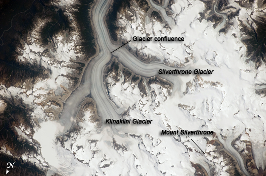 |
| Heiltskuk Icefield, British Columbia, Canada The Heiltskuk (also written Ha-Iltzuk) Icefield covers an area of approximately 3,600 square kilometers (1,389 square miles) in the southern Coast Mountains of British Columbia. This detailed astronaut photograph illustrates the icefield--mostly covered by snow across the upper mountain slopes--and two major valley glaciers that extend from it. Valley glaciers are large masses of slowly flowing ice and entrained debris that move downhill, carving out wide U-shaped valleys in the process. The locations of former valley glaciers can frequently be identified by the presence of these U-shaped valleys on a now glacier-free landscape. The two largest valley glaciers in the image, Silverthrone Glacier and Klinaklini Glacier, both flow towards Knight Inlet to the south (not shown). Several moraines--accumulations of rock and soil debris along the edges and surface of a glacier--are drawn out into long, dark lines by the flowing ice, and they extend along the length of both glaciers. The confluence of the two glaciers at image center illustrates how a moraine located along the side of a glacier can become a medial moraine, in the center of the joined ice mass. Smaller valley glaciers are visible near Mount Silverthrone. |
| Images: | All Available Images Low-Resolution 228k |
|
| Mission: | ISS020 |
|
| Roll - Frame: | E - 29216 |
|
| Geographical Name: | CANADA-BC |
|
| Features: | HA-ILTZUK ICEFIELD,SILVERTHRONE GLACIER,KLINAKLINI GLACIER |
|
| Center Lat x Lon: | 51.5N x 125.9W |
|
| Film Exposure: | N=Normal exposure, U=Under exposed, O=Over exposed, F=out of Focus |
|
| Percentage of Cloud Cover-CLDP: | 10 |
|
| Camera:: | N3 |
|
| Camera Tilt: | 32 | LO=Low Oblique, HO=High Oblique, NV=Near Vertical |
| Camera Focal Length: | 400 |
|
| Nadir to Photo Center Direction: | N | The direction from the nadir to the center point, N=North, S=South, E=East, W=West |
| Stereo?: | Y=Yes there is an adjacent picture of the same area, N=No there isn't |
|
| Orbit Number: | 1394 |
|
| Date: | 20090806 | YYYYMMDD |
| Time: | 215752 | GMT HHMMSS |
| Nadir Lat: | 49.7N |
Latitude of suborbital point of spacecraft |
| Nadir Lon: | 126.7W |
Longitude of suborbital point of spacecraft |
| Sun Azimuth: | 215 | Clockwise angle in degrees from north to the sun measured at the nadir point |
| Space Craft Altitude: | 187 | nautical miles |
| Sun Elevation: | 53 | Angle in degrees between the horizon and the sun, measured at the nadir point |
| Land Views: | GLACIER, MOUNTAIN, VALLEY |
|
| Water Views: | ICE |
|
| Atmosphere Views: | |
|
| Man Made Views: | |
|
| City Views: | |
|
Photo is not associated with any sequences | ||
| NASA Home Page |
JSC Home Page |
JSC Digital Image Collection |
Earth Science & Remote Sensing |
|
This service is provided by the International Space Station program and the JSC Earth Science & Remote Sensing Unit, ARES Division, Exploration Integration Science Directorate.

|