
Geographic Region: UKRAINE
Feature: SEVASTOPOL, C. KHERSONESSKIY, FOR., AGR., HILLS
|
Geographic Region: UKRAINE Feature: SEVASTOPOL, C. KHERSONESSKIY, FOR., AGR., HILLS |
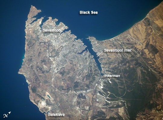 |
| Sevastopol, Ukraine The port city of Sevastopol is located in southernmost Ukraine on the Crimean Peninsula. The city is an important naval base due to the numerous inlets and bays along the coastline. During the Cold War, the city was the base of the Soviet Black Sea Fleet, but now it services vessels of both the Ukraine and Russia. The main economy of the city is based on trade and shipbuilding, but Sevastopol is also a popular tourist and resort destination for visitors from the Commonwealth of Independent Countries (formed from former Soviet Republics). This astronaut photograph highlights the jagged coastline of the southern Crimean Peninsula and the various docking areas of Sevastopol. The urban area is light gray, and it is bounded to the north and west by the Black Sea, to the south by vegetated (light green) and fallow (tan) agricultural fields, and to the east by the city of Inkerman and vegetated uplands (deep green). The city of Balaklava, to the south, houses another relic of the Cold War--an underground Soviet submarine base that is now open to the public as a monument. The Chernaya River issues into the Black Sea near Inkerman, flowing into the Sevastopol Inlet to the west. |
| Images: | All Available Images Low-Resolution 238k |
|
| Mission: | ISS020 |
|
| Roll - Frame: | E - 28072 |
|
| Geographical Name: | UKRAINE |
|
| Features: | SEVASTOPOL, C. KHERSONESSKIY, FOR., AGR., HILLS |
|
| Center Lat x Lon: | 44.6N x 33.5E |
|
| Film Exposure: | N=Normal exposure, U=Under exposed, O=Over exposed, F=out of Focus |
|
| Percentage of Cloud Cover-CLDP: | 10 |
|
| Camera:: | N3 |
|
| Camera Tilt: | 20 | LO=Low Oblique, HO=High Oblique, NV=Near Vertical |
| Camera Focal Length: | 400 |
|
| Nadir to Photo Center Direction: | N | The direction from the nadir to the center point, N=North, S=South, E=East, W=West |
| Stereo?: | Y=Yes there is an adjacent picture of the same area, N=No there isn't |
|
| Orbit Number: | 1369 |
|
| Date: | 20090805 | YYYYMMDD |
| Time: | 074040 | GMT HHMMSS |
| Nadir Lat: | 43.6N |
Latitude of suborbital point of spacecraft |
| Nadir Lon: | 34.0E |
Longitude of suborbital point of spacecraft |
| Sun Azimuth: | 124 | Clockwise angle in degrees from north to the sun measured at the nadir point |
| Space Craft Altitude: | 187 | nautical miles |
| Sun Elevation: | 52 | Angle in degrees between the horizon and the sun, measured at the nadir point |
| Land Views: | PENINSULA |
|
| Water Views: | INLET, RIVER, SEA |
|
| Atmosphere Views: | |
|
| Man Made Views: | RESORT, URBAN AREA, PORT |
|
| City Views: | |
|
Photo is not associated with any sequences | ||
| NASA Home Page |
JSC Home Page |
JSC Digital Image Collection |
Earth Science & Remote Sensing |
|
This service is provided by the International Space Station program and the JSC Earth Science & Remote Sensing Unit, ARES Division, Exploration Integration Science Directorate.

|