Geographic Region: CANARY ISLANDS
Feature: TEIDE VOLCANO, CALDERA, LAVA FLOWS, RAVINES
|
Geographic Region: CANARY ISLANDS Feature: TEIDE VOLCANO, CALDERA, LAVA FLOWS, RAVINES |
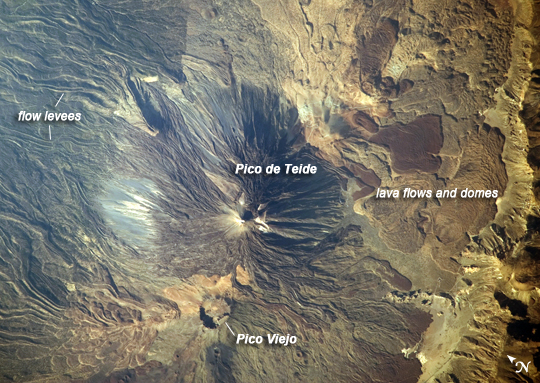 |
| Teide Volcano, Canary Islands, Spain This detailed astronaut photograph features two stratovolcanoes--Pico de Teide and Pico Viejo--located on Tenerife Island, part of the Canary Islands of Spain. Stratovolcanoes are steep-sided, typically conical volcanoes formed by interwoven layers of lava and fragmented rock material from explosive eruptions. Pico de Teide has a relatively sharp peak, whereas an explosion crater forms the summit of Pico Viejo. The two stratovolcanoes formed within an even larger volcanic structure known as the Las Canadas caldera. A caldera is a large collapse depression usually formed when a major eruption completely empties the magma chamber underlying a volcano. The last eruption of Teide occurred in 1909. Sinuous flow levees marking individual lava flows are perhaps the most striking volcanic features visible in the image. Flow levees are formed when the outer edges of a channelized lava flow cool and harden while the still-molten interior continues to flow downhill. Numerous examples radiate outwards from the peaks of both Pico de Teide and Pico Viejo. Brown to tan overlapping lava flows and domes are visible to the east-southeast of the Teide stratovolcano. Increased seismicity, carbon dioxide emissions, and fumarolic (gas and smoke) activity within the Las Canadas caldera and along the northwestern flanks of the volcano were observed in 2004. Monitoring of the volcano to detect renewal of activity is ongoing. |
| Images: | All Available Images Low-Resolution 308k |
|
| Mission: | ISS020 |
|
| Roll - Frame: | E - 21140 |
|
| Geographical Name: | CANARY ISLANDS |
|
| Features: | TEIDE VOLCANO, CALDERA, LAVA FLOWS, RAVINES |
|
| Center Lat x Lon: | 28.3N x 16.6W |
|
| Film Exposure: | N=Normal exposure, U=Under exposed, O=Over exposed, F=out of Focus |
|
| Percentage of Cloud Cover-CLDP: | 10 |
|
| Camera:: | N3 |
|
| Camera Tilt: | 41 | LO=Low Oblique, HO=High Oblique, NV=Near Vertical |
| Camera Focal Length: | 800 |
|
| Nadir to Photo Center Direction: | SW | The direction from the nadir to the center point, N=North, S=South, E=East, W=West |
| Stereo?: | Y=Yes there is an adjacent picture of the same area, N=No there isn't |
|
| Orbit Number: | 1045 |
|
| Date: | 20090715 | YYYYMMDD |
| Time: | 175304 | GMT HHMMSS |
| Nadir Lat: | 30.1N |
Latitude of suborbital point of spacecraft |
| Nadir Lon: | 14.6W |
Longitude of suborbital point of spacecraft |
| Sun Azimuth: | 281 | Clockwise angle in degrees from north to the sun measured at the nadir point |
| Space Craft Altitude: | 188 | nautical miles |
| Sun Elevation: | 25 | Angle in degrees between the horizon and the sun, measured at the nadir point |
| Land Views: | CALDERA, CRATER, ISLAND, VOLCANO |
|
| Water Views: | |
|
| Atmosphere Views: | |
|
| Man Made Views: | |
|
| City Views: | |
|
Photo is not associated with any sequences | ||
| NASA Home Page |
JSC Home Page |
JSC Digital Image Collection |
Earth Science & Remote Sensing |
|
This service is provided by the International Space Station program and the JSC Earth Science & Remote Sensing Unit, ARES Division, Exploration Integration Science Directorate.

|