Geographic Region: KIRIBATI
Feature: MILLENNIUM ISLAND, LAGOON, REEFS
|
Geographic Region: KIRIBATI Feature: MILLENNIUM ISLAND, LAGOON, REEFS |
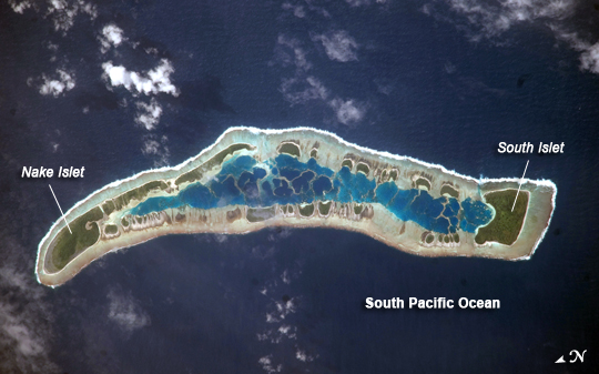 |
| Millennium Island, Kiribati Millennium Island--known as Caroline Island prior to 2000--is located at the southern end of the Line Islands in the South Pacific Ocean. This uninhabited island is part of the Republic of Kiribati, an island nation comprised of 32 atolls (including Millennium Island) and one raised coral island. Millennium Island is formed from a number of smaller islets built on coral reefs. The coral reefs grew around a now-submerged volcanic peak, leaving a ring of coral around an inner lagoon. The islands above the waterline are composed primarily of limestone rock and sand derived from the reefs. At a maximum height of approximately 6 meters (19.7 feet) above sea level, Millennium Island has been identified as being at great risk from sea level rise by the United Nations. The islets of Millennium Island are readily visible in this astronaut photograph as irregular green vegetated areas surrounding the inner lagoon. The shallow lagoon waters are a lighter blue than the deeper surrounding ocean water; tan linear "fingers" within the lagoon are the tops of corals. The two largest islets are Nake Islet and South Islet, located at the north and south ends of Millennium Island respectively. The ecosystem of Millennium Island is considered to be relatively pristine despite periods of human habitation, guano mining, and agricultural activities, and the island has been recommended as both a World Heritage site and Biosphere Reserve. |
| Images: | All Available Images Low-Resolution 177k |
|
| Mission: | ISS020 |
|
| Roll - Frame: | E - 16279 |
|
| Geographical Name: | KIRIBATI |
|
| Features: | MILLENNIUM ISLAND, LAGOON, REEFS |
|
| Center Lat x Lon: | 10S x 150.2W |
|
| Film Exposure: | N=Normal exposure, U=Under exposed, O=Over exposed, F=out of Focus |
|
| Percentage of Cloud Cover-CLDP: | 10 |
|
| Camera:: | N3 |
|
| Camera Tilt: | 24 | LO=Low Oblique, HO=High Oblique, NV=Near Vertical |
| Camera Focal Length: | 800 |
|
| Nadir to Photo Center Direction: | N | The direction from the nadir to the center point, N=North, S=South, E=East, W=West |
| Stereo?: | Y=Yes there is an adjacent picture of the same area, N=No there isn't |
|
| Orbit Number: | 825 |
|
| Date: | 20090701 | YYYYMMDD |
| Time: | 192213 | GMT HHMMSS |
| Nadir Lat: | 11.3S |
Latitude of suborbital point of spacecraft |
| Nadir Lon: | 149.7W |
Longitude of suborbital point of spacecraft |
| Sun Azimuth: | 49 | Clockwise angle in degrees from north to the sun measured at the nadir point |
| Space Craft Altitude: | 186 | nautical miles |
| Sun Elevation: | 38 | Angle in degrees between the horizon and the sun, measured at the nadir point |
| Land Views: | ISLAND |
|
| Water Views: | LAGOON, OCEAN |
|
| Atmosphere Views: | |
|
| Man Made Views: | |
|
| City Views: | |
|
Photo is not associated with any sequences | ||
| NASA Home Page |
JSC Home Page |
JSC Digital Image Collection |
Earth Science & Remote Sensing |
|
This service is provided by the International Space Station program and the JSC Earth Science & Remote Sensing Unit, ARES Division, Exploration Integration Science Directorate.

|