Geographic Region: CHINA
Feature: YANGTZE R. V., MTS., FOR., THREE GORGES DAM
|
Geographic Region: CHINA Feature: YANGTZE R. V., MTS., FOR., THREE GORGES DAM |
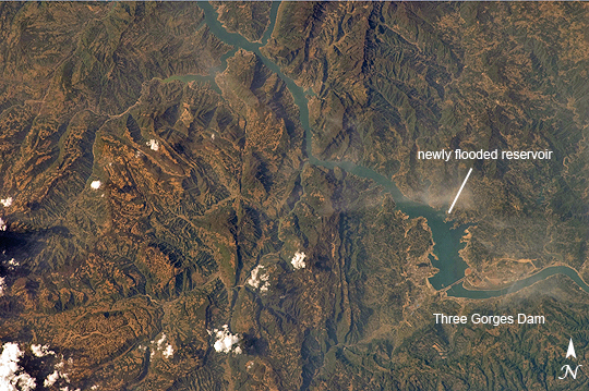 |
| Three Gorges Dam, China A new reservoir is filling in central China. The Three Gorges Dam on the Yangtze River--the world's largest dam--was completed in 2006, and the river is filling up its valley behind the dam to form a narrow reservoir extending more than 600 kilometers. This image from April 15, 2009, is one of the first images that astronauts on the International Space Station have been able to capture of the flooding behind the dam. The main objective for the dam is to supply water for the largest hydroelectric plant in the world and to help control the devastating floods that plague the lowlands downstream from the dam. The epic scale of the dam project is matched by the level of controversy it continues to generate. Concerns about major environmental impacts, the relocation of 1.2 million people, and the flooding of 13 cities, more than 1300 villages, archeological locations, and hazardous waste dumps were raised throughout the planning and implementation. Environmental concerns include increased seismicity from the loading of the water, landslides, changed ecosystems, accumulated pollution, increased chances for waterborne diseases, and salinity changes in the Yangtze estuary. |
| Images: | All Available Images Low-Resolution 336k |
|
| Mission: | ISS019 |
|
| Roll - Frame: | E - 7720 |
|
| Geographical Name: | CHINA |
|
| Features: | YANGTZE R. V., MTS., FOR., THREE GORGES DAM |
|
| Center Lat x Lon: | 30.9N x 110.8E |
|
| Film Exposure: | N=Normal exposure, U=Under exposed, O=Over exposed, F=out of Focus |
|
| Percentage of Cloud Cover-CLDP: | 10 |
|
| Camera:: | N2 |
|
| Camera Tilt: | 27 | LO=Low Oblique, HO=High Oblique, NV=Near Vertical |
| Camera Focal Length: | 180 |
|
| Nadir to Photo Center Direction: | NW | The direction from the nadir to the center point, N=North, S=South, E=East, W=West |
| Stereo?: | Y=Yes there is an adjacent picture of the same area, N=No there isn't |
|
| Orbit Number: | 3605 |
|
| Date: | 20090415 | YYYYMMDD |
| Time: | 070522 | GMT HHMMSS |
| Nadir Lat: | 30.1N |
Latitude of suborbital point of spacecraft |
| Nadir Lon: | 112.2E |
Longitude of suborbital point of spacecraft |
| Sun Azimuth: | 249 | Clockwise angle in degrees from north to the sun measured at the nadir point |
| Space Craft Altitude: | 189 | nautical miles |
| Sun Elevation: | 49 | Angle in degrees between the horizon and the sun, measured at the nadir point |
| Land Views: | VALLEY |
|
| Water Views: | RESERVOIR, RIVER |
|
| Atmosphere Views: | |
|
| Man Made Views: | DAM |
|
| City Views: | |
|
Photo is not associated with any sequences | ||
| NASA Home Page |
JSC Home Page |
JSC Digital Image Collection |
Earth Science & Remote Sensing |
|
This service is provided by the International Space Station program and the JSC Earth Science & Remote Sensing Unit, ARES Division, Exploration Integration Science Directorate.

|