
Geographic Region: USA-NORTH DAKOTA
Feature: WAHPETON-BREKENRIDGE, FLOODING
|
Geographic Region: USA-NORTH DAKOTA Feature: WAHPETON-BREKENRIDGE, FLOODING |
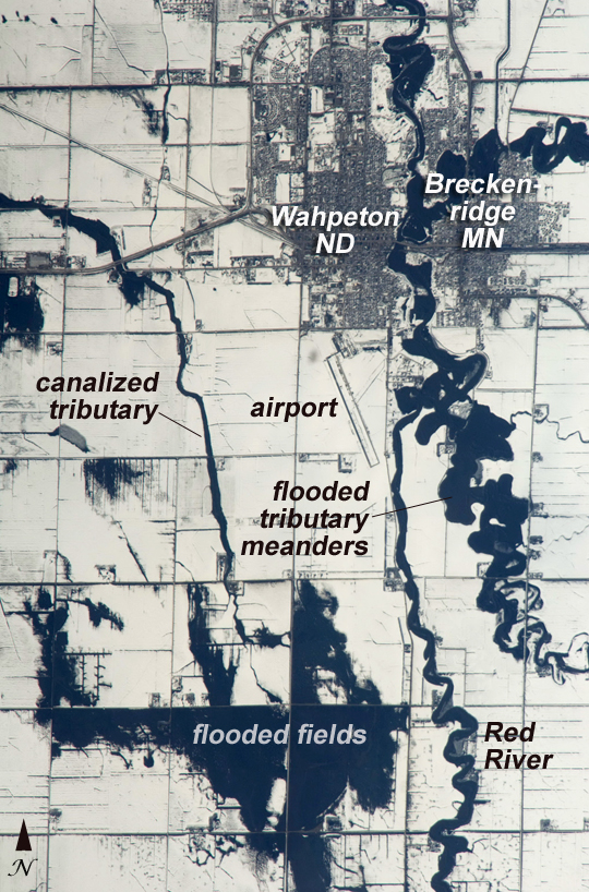 |
| Red River Floods, North Dakota and Minnesota When this astronaut photo was captured on April 9, 2009, the Red River was experiencing its second round of spring flooding. (Two weeks earlier, the river had crested at very high levels.) The Red River flows north between North Dakota and Minnesota from the confluence of the Bois de Sioux River (south, image lower right) and the less well drained, meandering Otter Tail River (east, image right). Floodwaters in these two tributaries appear as black shapes against a snowy agricultural landscape that is defined by rectangular fields. The largest flooded areas are low parts of fields (image bottom) along a canalized western tributary of the Wild Rice River, which itself becomes a tributary of the Red River just south of Fargo, North Dakota. Wahpeton, North Dakota, and Breckenridge, Minnesota, sit opposite each another on the banks of the Red River, and their city-block patterns stand out as dark gray patches against the snow at image top right. The main runway of the Henry Stern Airport lies angled northwest directly south of Wahpeton, and its 1.3-kilometers (0.8-mile) runway gives a sense of scale to the photo. Access roads to the agricultural fields tend to follow an orthogonal pattern, while larger roads leading to the cities cut across this pattern (image upper left, near Wahpeton). A subtle pattern of drainage ditches and plow lines appears as thin, parallel lines throughout fields in the scene. |
| Images: | All Available Images Low-Resolution 515k |
|
| Mission: | ISS019 |
|
| Roll - Frame: | E - 5989 |
|
| Geographical Name: | USA-NORTH DAKOTA |
|
| Features: | WAHPETON-BREKENRIDGE, FLOODING |
|
| Center Lat x Lon: | 46.2N x 96.6W |
|
| Film Exposure: | N=Normal exposure, U=Under exposed, O=Over exposed, F=out of Focus |
|
| Percentage of Cloud Cover-CLDP: | 10 |
|
| Camera:: | N2 |
|
| Camera Tilt: | 21 | LO=Low Oblique, HO=High Oblique, NV=Near Vertical |
| Camera Focal Length: | 800 |
|
| Nadir to Photo Center Direction: | W | The direction from the nadir to the center point, N=North, S=South, E=East, W=West |
| Stereo?: | Y=Yes there is an adjacent picture of the same area, N=No there isn't |
|
| Orbit Number: | 3520 |
|
| Date: | 20090409 | YYYYMMDD |
| Time: | 211805 | GMT HHMMSS |
| Nadir Lat: | 46.0N |
Latitude of suborbital point of spacecraft |
| Nadir Lon: | 95.4W |
Longitude of suborbital point of spacecraft |
| Sun Azimuth: | 239 | Clockwise angle in degrees from north to the sun measured at the nadir point |
| Space Craft Altitude: | 188 | nautical miles |
| Sun Elevation: | 37 | Angle in degrees between the horizon and the sun, measured at the nadir point |
| Land Views: | |
|
| Water Views: | RIVER |
|
| Atmosphere Views: | |
|
| Man Made Views: | AIRPORT |
|
| City Views: | |
|
Photo is not associated with any sequences | ||
| NASA Home Page |
JSC Home Page |
JSC Digital Image Collection |
Earth Science & Remote Sensing |
|
This service is provided by the International Space Station program and the JSC Earth Science & Remote Sensing Unit, ARES Division, Exploration Integration Science Directorate.

|