
Geographic Region: CROATIA
Feature: SPLIT, BRACKI CHAN.,MTS.,ROADS
|
Geographic Region: CROATIA Feature: SPLIT, BRACKI CHAN.,MTS.,ROADS |
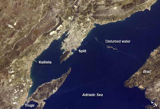 |
| Dalmatian Coastline near Split, Croatia One the world's most rugged coastlines is located in Croatia along the Adriatic Sea. This astronaut photograph features the Dalmatian coastline of Croatia around the city of Split. Much of the region's topography is characterized by northwest-southeast-oriented islands and embayments of the Adriatic Sea. These distinctive coastal land forms result from faulting (caused by tectonic activity in the region) and sea level rise since the end of the last ice age. Split has a long history of human settlement. The Roman Emperor Diocletian retired to Spalatum (present-day Split) in 305, and his palace constitutes the core of the city today. The city is a popular resort destination for its historic sites, Mediterranean climate, and ready access to Adriatic Sea islands (such as Brae, to the south). Other large cities in the region include Kastela and Trogir; together with Split, these form an almost continuous urban corridor along the coast (visible as pink regions in the image). A thin zone of disturbed water (tan patches) marking a water boundary appears in the Adriatic Sea between Split and the island of Brae. It may be a plankton bloom or a line of convergence between water masses, which creates rougher water. A unique combination of features--including dramatic topography that channels local winds, the complicated coastline, input of fresh water from rivers, and ample nutrients and natural surface oils--produce interesting mesoscale surface dynamics throughout the Adriatic Sea. Over the years, astronauts have taken images of the Split region using sunglint (the mirror-like reflection of the Sun off water) and changes in water color to highlight features like eddies, water boundaries and mixing zones between fresh waters flowing into the saltier (denser) waters of the Adriatic, and wind-driven surface currents. Split is an important transit center connecting islands in the Adriatic Sea to the Italian peninsula, and it is an important regional manufacturing center of goods such as solar cells, plastics, and paper products. The city was heavily industrialized during the post-World War II period as a member state of Yugoslavia. By the 1980s, the marine environment bordered by Split, Kastela, and Trogir (known as Kastela Bay) had become one of the most polluted areas of the Adriatic, both from sewage and industrial pollution. Concerted efforts by the Croatian government and international partners to improve waste handling and treatment infrastructure over the past 10 years seem to have been successful in improving water quality. |
| Images: | All Available Images Low-Resolution 236k |
|
| Mission: | ISS019 |
|
| Roll - Frame: | E - 5501 |
|
| Geographical Name: | CROATIA |
|
| Features: | SPLIT, BRACKI CHAN.,MTS.,ROADS |
|
| Center Lat x Lon: | 43.5N x 16.5E |
|
| Film Exposure: | N=Normal exposure, U=Under exposed, O=Over exposed, F=out of Focus |
|
| Percentage of Cloud Cover-CLDP: | 10 |
|
| Camera:: | N2 |
|
| Camera Tilt: | 29 | LO=Low Oblique, HO=High Oblique, NV=Near Vertical |
| Camera Focal Length: | 180 |
|
| Nadir to Photo Center Direction: | W | The direction from the nadir to the center point, N=North, S=South, E=East, W=West |
| Stereo?: | Y=Yes there is an adjacent picture of the same area, N=No there isn't |
|
| Orbit Number: | 3512 |
|
| Date: | 20090409 | YYYYMMDD |
| Time: | 085237 | GMT HHMMSS |
| Nadir Lat: | 44.0N |
Latitude of suborbital point of spacecraft |
| Nadir Lon: | 18.2E |
Longitude of suborbital point of spacecraft |
| Sun Azimuth: | 136 | Clockwise angle in degrees from north to the sun measured at the nadir point |
| Space Craft Altitude: | 190 | nautical miles |
| Sun Elevation: | 46 | Angle in degrees between the horizon and the sun, measured at the nadir point |
| Land Views: | COAST, ISLAND |
|
| Water Views: | BAY, PLANKTON BLOOM, SEA |
|
| Atmosphere Views: | |
|
| Man Made Views: | RESORT, URBAN AREA |
|
| City Views: | |
|
Photo is not associated with any sequences | ||
| NASA Home Page |
JSC Home Page |
JSC Digital Image Collection |
Earth Science & Remote Sensing |
|
This service is provided by the International Space Station program and the JSC Earth Science & Remote Sensing Unit, ARES Division, Exploration Integration Science Directorate.

|