Geographic Region: JAPAN
Feature: MT. FUJI, LAND USE
|
Geographic Region: JAPAN Feature: MT. FUJI, LAND USE |
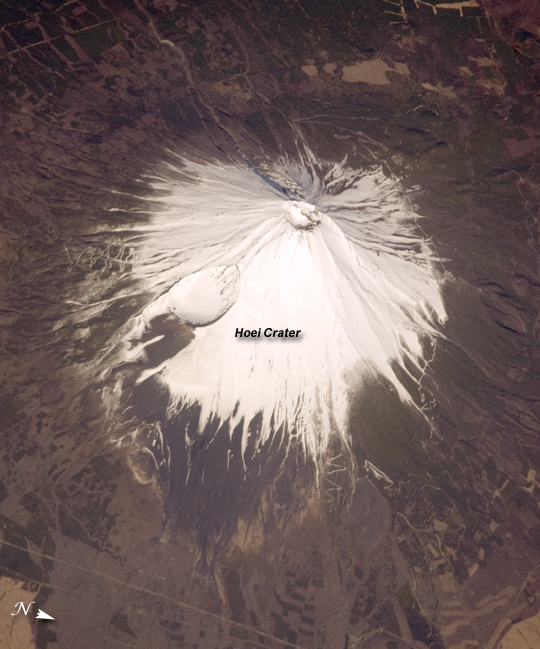 |
| Mount Fuji, Japan The 3,776 meter high Mount Fuji volcano, located on the island of Honshu in Japan, is one of the world's classic examples of a stratovolcano. The volcano's steep, conical profile is the result of numerous interlayered lava flows and explosive eruption products - such as ash, cinders, and volcanic bombs - building up the volcano over time. The steep profile is possible because of the relatively high viscosity of the volcanic rocks typically associated with stratovolcanoes. This leads to thick sequences of lava flows near the eruptive vent that build the cone structure, rather than low viscosity flows that spread out over the landscape and build lower-profile shield volcanoes . Mount Fuji, or Fuji-san in Japan, is actually comprised of several overlapping volcanoes that began erupting in the Pleistocene Epoch (1.8 million to approximately 10,000 years ago). The currently active volcano, known as Younger Fuji, began forming approximately 11,000 to 8,000 years ago. The most recent explosive activity occurred in 1707, creating Hoei Crater on the southeastern flank of the volcano (image center). This eruption deposited ash on Edo (present-day Tokyo) located 95 km to the northeast. While there have been no further eruptions of Mount Fuji, steam was observed at the summit during 1780 - 1820, and the volcano is considered active. |
| Images: | All Available Images Low-Resolution 298k |
|
| Mission: | ISS019 |
|
| Roll - Frame: | E - 5286 |
|
| Geographical Name: | JAPAN |
|
| Features: | MT. FUJI, LAND USE |
|
| Center Lat x Lon: | 35.4N x 138.8E |
|
| Film Exposure: | N=Normal exposure, U=Under exposed, O=Over exposed, F=out of Focus |
|
| Percentage of Cloud Cover-CLDP: | 10 |
|
| Camera:: | N3 |
|
| Camera Tilt: | 47 | LO=Low Oblique, HO=High Oblique, NV=Near Vertical |
| Camera Focal Length: | 800 |
|
| Nadir to Photo Center Direction: | W | The direction from the nadir to the center point, N=North, S=South, E=East, W=West |
| Stereo?: | Y=Yes there is an adjacent picture of the same area, N=No there isn't |
|
| Orbit Number: | 3506 |
|
| Date: | 20090408 | YYYYMMDD |
| Time: | 233914 | GMT HHMMSS |
| Nadir Lat: | 34.3N |
Latitude of suborbital point of spacecraft |
| Nadir Lon: | 142.0E |
Longitude of suborbital point of spacecraft |
| Sun Azimuth: | 113 | Clockwise angle in degrees from north to the sun measured at the nadir point |
| Space Craft Altitude: | 191 | nautical miles |
| Sun Elevation: | 42 | Angle in degrees between the horizon and the sun, measured at the nadir point |
| Land Views: | CRATER, ISLAND, VOLCANO |
|
| Water Views: | |
|
| Atmosphere Views: | |
|
| Man Made Views: | |
|
| City Views: | |
|
Photo is not associated with any sequences | ||
| NASA Home Page |
JSC Home Page |
JSC Digital Image Collection |
Earth Science & Remote Sensing |
|
This service is provided by the International Space Station program and the JSC Earth Science & Remote Sensing Unit, ARES Division, Exploration Integration Science Directorate.

|