
Geographic Region: CHILE
Feature: EVAPORATION PONDS,PAMPA DEL TAMARUGAL
|
Geographic Region: CHILE Feature: EVAPORATION PONDS,PAMPA DEL TAMARUGAL |
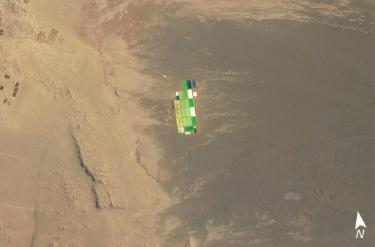 |
| Solar Evaporation Ponds, Atacama Desert Brightly colored solar evaporation (salt) ponds in a desert landscape give this astronaut photo an unreal quality. The ponds sit near the foot of a long alluvial fan in the Pampa del Tamarugal, the great hyper-arid inner valley of Chile's Atacama Desert. The alluvial fan sediments are dark brown, and they contrast sharply with tan sediments of the Pampa del Tamarugal. Nitrates and many other minerals are mined in this region. A few extraction pits and ore dumps are visible at upper left. Iodine is one of the products from mining; it is first extracted by heap leaching. Waste liquids from the iodine plants are dried in the tan and brightly colored evaporation ponds to crystallize nitrate salts for collection. The recovered nitrates are mainly used for fertilizer for higher-value crops. They are also used in the manufacture of pharmaceuticals, explosives, glass, and ceramics, as well as in water treatment and metallurgical processes. |
| Images: | All Available Images Low-Resolution 180k |
|
| Mission: | ISS019 |
|
| Roll - Frame: | E - 14473 |
|
| Geographical Name: | CHILE |
|
| Features: | EVAPORATION PONDS,PAMPA DEL TAMARUGAL |
|
| Center Lat x Lon: | 20.9S x 69.5W |
|
| Film Exposure: | N=Normal exposure, U=Under exposed, O=Over exposed, F=out of Focus |
|
| Percentage of Cloud Cover-CLDP: | 10 |
|
| Camera:: | N2 |
|
| Camera Tilt: | 16 | LO=Low Oblique, HO=High Oblique, NV=Near Vertical |
| Camera Focal Length: | 400 |
|
| Nadir to Photo Center Direction: | NW | The direction from the nadir to the center point, N=North, S=South, E=East, W=West |
| Stereo?: | Y=Yes there is an adjacent picture of the same area, N=No there isn't |
|
| Orbit Number: | 3924 |
|
| Date: | 20090505 | YYYYMMDD |
| Time: | 135655 | GMT HHMMSS |
| Nadir Lat: | 21.7S |
Latitude of suborbital point of spacecraft |
| Nadir Lon: | 69.1W |
Longitude of suborbital point of spacecraft |
| Sun Azimuth: | 48 | Clockwise angle in degrees from north to the sun measured at the nadir point |
| Space Craft Altitude: | 193 | nautical miles |
| Sun Elevation: | 36 | Angle in degrees between the horizon and the sun, measured at the nadir point |
| Land Views: | ALLUVIAL FAN, DESERT, VALLEY |
|
| Water Views: | |
|
| Atmosphere Views: | |
|
| Man Made Views: | MINING |
|
| City Views: | |
|
Photo is not associated with any sequences | ||
| NASA Home Page |
JSC Home Page |
JSC Digital Image Collection |
Earth Science & Remote Sensing |
|
This service is provided by the International Space Station program and the JSC Earth Science & Remote Sensing Unit, ARES Division, Exploration Integration Science Directorate.

|