Geographic Region: USA-HAWAII
Feature: HAWAII ISLAND,MAUNA KEA VOLCANCO,CINDER CONES
|
Geographic Region: USA-HAWAII Feature: HAWAII ISLAND,MAUNA KEA VOLCANCO,CINDER CONES |
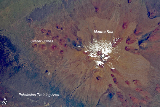 |
| Mauna Kea The island of Hawaii is home to four volcanoes monitored by volcanologists: Mauna Loa, Hualalai, Kilauea, and Mauna Kea. Mauna Kea is depicted in this astronaut photograph; of the four volcanoes, it is the only one that has not erupted during historical times. The Hawaiian Islands chain, together with the submerged Emperor chain to the northwest, forms an extended line of volcanic islands and seamounts that is thought to record passage of the Pacific Plate over a hotspot (or thermal plume) in the Earth's mantle. Areas of active volcanism in the southern Hawaiian Islands today mark the general location of the hotspot. This detailed astronaut photograph illustrates why the volcano is called Mauna Kea (white mountain in Hawaiian). While the neighboring Mauna Loa volcano is a classic shield volcano comprised of dark basaltic lava flows, Mauna Kea experienced more explosive activity during its last eruptive phase. This covered its basalt lava flows with pyroclastic deposits. In addition, former glaciers at the summit of the volcano left till deposits--sediments deposited directly in place as the glacial ice melted. The majority of these deposits are visible as light brown areas to the north and southeast of the white snow at image center. Numerous small red to dark gray cinder cones are another distinctive feature of Mauna Kea. The cinder cones represent the most recent type of volcanic activity at the volcano. |
| Images: | All Available Images Low-Resolution 242k |
|
| Mission: | ISS019 |
|
| Roll - Frame: | E - 11922 |
|
| Geographical Name: | USA-HAWAII |
|
| Features: | HAWAII ISLAND,MAUNA KEA VOLCANCO,CINDER CONES |
|
| Center Lat x Lon: | 19.8N x 155.5W |
|
| Film Exposure: | N=Normal exposure, U=Under exposed, O=Over exposed, F=out of Focus |
|
| Percentage of Cloud Cover-CLDP: | 10 |
|
| Camera:: | N2 |
|
| Camera Tilt: | 18 | LO=Low Oblique, HO=High Oblique, NV=Near Vertical |
| Camera Focal Length: | 400 |
|
| Nadir to Photo Center Direction: | SW | The direction from the nadir to the center point, N=North, S=South, E=East, W=West |
| Stereo?: | Y=Yes there is an adjacent picture of the same area, N=No there isn't |
|
| Orbit Number: | 3818 |
|
| Date: | 20090428 | YYYYMMDD |
| Time: | 200304 | GMT HHMMSS |
| Nadir Lat: | 20.3N |
Latitude of suborbital point of spacecraft |
| Nadir Lon: | 154.6W |
Longitude of suborbital point of spacecraft |
| Sun Azimuth: | 95 | Clockwise angle in degrees from north to the sun measured at the nadir point |
| Space Craft Altitude: | 191 | nautical miles |
| Sun Elevation: | 58 | Angle in degrees between the horizon and the sun, measured at the nadir point |
| Land Views: | ISLAND, MOUNTAIN, VOLCANO |
|
| Water Views: | |
|
| Atmosphere Views: | |
|
| Man Made Views: | |
|
| City Views: | |
|
Photo is not associated with any sequences | ||
| NASA Home Page |
JSC Home Page |
JSC Digital Image Collection |
Earth Science & Remote Sensing |
|
This service is provided by the International Space Station program and the JSC Earth Science & Remote Sensing Unit, ARES Division, Exploration Integration Science Directorate.

|